Thursday, August 23, 2007
Everything is OKAY!
We just finished up putting the bus back together. Yesterday, all the parts came with UPS as we were having dinner with the Thurstons. So we all got to work (John even helped) after dinner. We finished it this morning, and Romy took it for a test drive before lunch. Everything is OKAY! So we are now relieved, and we'll be on our way into Nebraska.
Wednesday, August 22, 2007
Update about Colorado and Transmission
Hi Everybody who is concerned with the soap opera unfolding with the bus! We ordered all the parts yesterday to be shipped overnight to us here in Golden, CO. One of the two packages arrived this morning, and we are waiting on the second one (which contains the more important pieces). So, since yesterday afternoon, all we can do is wait and relax. Last night we had dinner with everybody. We had elk sausages with locally grown sweet corn.
This morning, we went for a bike ride with John. We went 13 miles up and down some mountains. Then we stopped for a cup of coffee, and saw some farmed buffalo. It was fun on the down-hill sections, but harder going up hill, but we made it, even though we were biking at 8000 feet!
This afternoon when the rest of the parts come, we will finish the job and stay here one more night. If all is well, tomorrow (Thursday) we should be leaving, but before we go, we would like to drive up Mt. Evans, which is just as high as Pike's Peak. I hope we make it!!!!
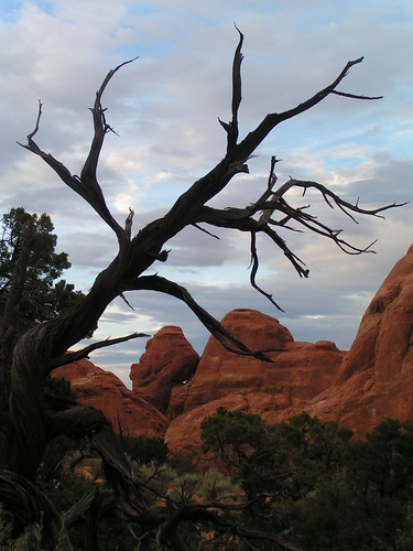
Also, we've put up our pictures from Arches National Park. Just click on the pic below to get directed to our flickr page of pictures:
This morning, we went for a bike ride with John. We went 13 miles up and down some mountains. Then we stopped for a cup of coffee, and saw some farmed buffalo. It was fun on the down-hill sections, but harder going up hill, but we made it, even though we were biking at 8000 feet!
This afternoon when the rest of the parts come, we will finish the job and stay here one more night. If all is well, tomorrow (Thursday) we should be leaving, but before we go, we would like to drive up Mt. Evans, which is just as high as Pike's Peak. I hope we make it!!!!
Also, we've put up our pictures from Arches National Park. Just click on the pic below to get directed to our flickr page of pictures:
Tuesday, August 21, 2007
Transmission Problems in Colorado
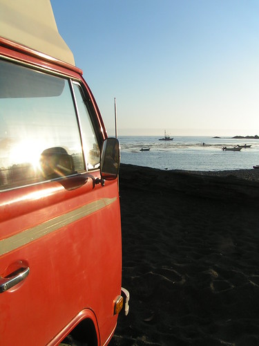
Well, since we last posted in Moab, we were doing all sorts of stuff. We went climbing, mountain biking, hiking in Arches NP, etc. Then we continued driving into Colorado on Sunday. We got all the way to Canon City, where we stopped for some Blizzards at Dairy Queen. When we came out of DQ, we started driving off, and noticed we couldn't get it into 3rd or 4th gear! Oh No! So we pulled over, and tried to read what might be wrong in the manuals and online (we conveniently had a wifi signal from some hotel next to us). We figured out that it might be a bushing on the shifter, so we checked, and it was missing! Yay, problem fixed, right? Except we didn't have the bushing, so we had to "make" one by jamming some wooden sticks and taping them secure with electrical tape. We drove off with 3rd and 4th, but we had no reverse. We made it to Golden, CO, where Romy's family is.
There, we found a VW parts place and got the bushing. We took it on a test drive to Buffalo Bill's, and discovered that the problem was NOT fixed!!!!!
So there we went, looking for what might really be the problem, which we figured must be something inside the transmission, not just on the shifter. So later that evening Romy dropped the engine and transmission.
This morning, we cleaned up the transmission and opened it. We discover that the ball joint inside was completely worn down, which made sense with what we read online. If the ball joint is worn down too much, then it can't push into 3rd and 4th, only 1st and 2nd gear. The trouble is now, how can we get the part in time? Its tuesday, and we need to be home soon!
Friday, August 17, 2007
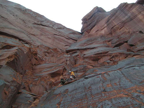
Climbing in Moab
Right now we're taking a break from the hot sun here at Moab, Utah. We just finished rock climbing (see the pictures on flickr, just click on the pic below and it'll link you to flickr). It was fun!
Now we're going to visit Arches NP.
Now we're going to visit Arches NP.
Thursday, August 16, 2007
Detailed, Long, Informative
Well, we didn’t have much time to write since we last posted. We said we were on our way to the Pacific coast. We drove across Oregon until we got to the Cascade Mts, and then we got to the coast. The Pacfic Northwest coast line is volcanic, and it was very rocky with rocks sticking out of the water close to the shoreline. It was foggy when we got to the coast, and remained foggy until we got to LA! Put there were some spots of sunshine, which was nice. We drove down the coast of Oregon, and upon entering California, we came to the Redwood National Park. You don’t really enter it, it is just an area along the coast of upper Cali which protects the Redwoods and Giant Sequoia trees.
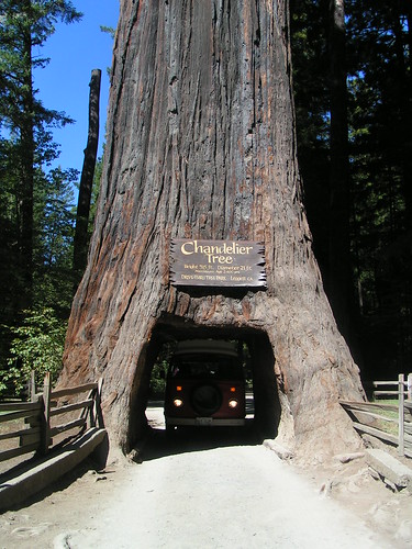
Big Trees
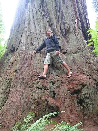
The Redwoods and Sequoias are sooooo huge! And they are very very old too. We learned that the biggest Redwoods and Sequoias are 2,000 to 3,000 years old!!! The trunks of the Sequoias are much thicker at the base, and tapers off as it goes up. The pines are also bushier. The Redwoods are slightly tinted red and the trunk of the trees is pretty much the same thickness all the way to the top, but thinner in general than the Sequoias. Redwoods are the tallest trees in any forest. They can be up to 370 ft and the Sequoias are about 300 ft. We visited one Redwood tree, called The Big Tree, which had a base circumference of 100ft! It was huge! We also almost drove thru one Sequoia (one of only 3 that have a huge hole in it to drive your car thru). Well, we were a couple of inches too tall to fit under all the way, but we would’ve fit otherwise.
San Fran
Then we started making our way down the coastal Highway 1 to San Francisco. The coast was very similar to the Oregon coast, with all the rockiness. We wanted to go check out University of California Berkeley, Stanford University, and University of California Davis (which was more towards Sacramento). The coast was usually foggy b/c of the cold water, but when you went inland about a mile, the sky was all clear with no clouds, sunny, and hot! We first visited the schools. We liked Berkeley the best b/c of the neighborhood around it and b/c the campus was nice. Stanford was very rich-y rich, with a high class neighborhood and a fancy campus, complete with fake transplanted palm trees. Davis was out in the middle of dry flat valley land, and the housing was actually expensive in that small town. After checking out the schools, we went to downtown San Fran and had the San Fran experience. All those hills are a bit crazy for the manual VW. There is one big hill in the center of the downtown area which was so steep, we had to drive up it in first gear! We almost stalled because we were following a trolley car so close, and it would randomly slow down and speed back up again! All this up a hill that had to be 45 degrees!
L.A.
Next, we started driving towards LA. Along the coast, we saw Elephant Seals! The males started fighting right in front of us. We also saw dolphins swimming in the water along the coast. We got to LA and were greeted by so much traffic and the Baywatch lifeguard towers on the beach. The beaches were actually nice for being right in a huge city. They were the only place where there were no cars and relatively no smog. The smog was so bad in the rest of the city that you couldn’t tell there was a whole mountain range right next to the city! We visited Julie, who was working at the California State University at Long Beach along with Molly. We bummed a free shower at the dorms, and then we headed off to the beach to relax. While we were in LA, we visited California Institute of Technology in Pasadena, which we liked the best out of the LA schools. Also we visited University of California Irvine, and Southern California University, which was in the downtown LA area. The other two were in suburbs. LA wasn’t spectacular, but it had nice beaches and nice location. On our way out of LA, we stopped at a VW salvage yard to pick up some parts we needed for our sliding door. So far nothing wrong with the engine or anything.
San Diego
Since San Diego was so close, we decided to drive down there because there was only one school left for us to see, which was University of California San Diego. It was actually in La Jolla, just north of SD. We liked San Diego better than LA. While we were there, we visited UCSD and the beaches. We went to spend a day at Silver Strand State Beach, and the sand looked like it had real pieces of sparkling silver or gold in the sand. It was neat! The waves were fun. The next day we had to leave and start our way back north-east. We decided to head out towards Las Vegas, Nevada.
DESERT!
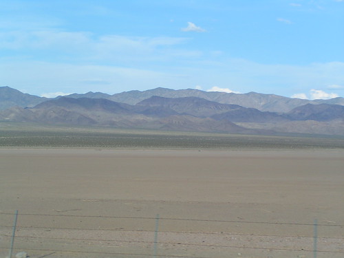
We had to first cross the Mojave Desert, which makes up most of California. It sucked! We got to Baker, Cali, which is in the middle of the desert, and the thermometer read 112 degrees! On top of no air-conditioning, we didn’t cool off much with the windows open- the air coming in to the car was over 100 degrees (maybe hotter), like standing in front of a heater. The desert had mini-mountains, which were very nice (maybe the only thing that made it OK). But we had to cross about three desert mountain ranges, which were very long, uphill sections where we could only go about 35mph, otherwise the poor VW would overheat. Nowhere have we seen so many cars pulled over on the side of the road with their hoods up, overheated. We even saw one Chinese tourist with his hood up, and he was trying to fan his engine with a piece of paper! Hahahaha!
Well, the sun was going down, and we were approaching Las Vegas and Lake Mead, where there was camping. We wanted to go swimming in the lake (which was created by the Hoover Dam) but by the time we got there it was too dark out. We saw a Jack Rabbit. We thought it might cool off at night, like deserts are supposed to do, but no. It stayed about 95 degree overnight. We couldn’t sleep at all. IT WAS SO HOT and NO WIND!!! All of a sudden, after the sun came up again in the morning, the wind picked up like a wind storm. Finally, some relief but we couldn’t sleep in too long cuz we wanted to go see the Hoover Dam and Vegas before noon time.
Vegas and The Hoover Dam
The Hoover Dam was really big and I liked the art deco styling of it. The lake it was holding back was low. The dam was something like 660 feet thick at the base and 45 feet at the top, where cars and people can go over it. After that, we went to go eat breakfast at a small diner in Boulder City. Next we went to Vegas, and drove down the strip. It was kind of gross. That’s all there is to say about it, other than the crazy lights and giant recreations of famous landmarks from around the world- New York, Paris, Venice, etc. Lots of people walking and getting entertained, drinking, and gambling. Boring!
We continued out of Nevada, into Arizona for a short amount of time, and then into Utah. Utah is beautiful! We began to come out of the desert (finally, because I was gonna melt soon), and into the “staircase”, an area of canyon-land from Bryce to Zion to the Grand Canyon which is like stairs, highest at Bryce and lowest at the Grand Canyon. The lowest rock layer at Bryce is the top layer at Zion. The lowest layer at Zion is the top rock layer in the Grand Canyon.
Zion National Park
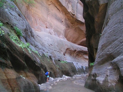
As we can into Zion, we thought we were entering a mountain range, but we were really going down into a huge canyon. We saw towering cliffs (about 2,000ft above our heads) of yellow, red, and brown sandstone. We took a shuttle into the canyon, and the guide told us how the canyon formed. The whole area was once a huge desert, like the Sahara Desert. Only this desert was covered in sand dunes 10 times as high as the dunes in the Sahara Desert today (which are about 300 feet high). So about 3,000 feet of sand dunes existed over our heads in the past. Then, as the climate shifted, a huge shallow ocean covered the desert, and the minerals from the water slowly seeped down into the sand below, cementing it into sandstone and also creating the colors. The reds came from iron oxide, or rust. Finally, when the ocean left, there was a hug flat meadow in its place. A river started flowing through it, called the Virgin River, and began to carve out a deep and narrow slit in the sandstone. Once it got down about 1-2,000 feet, it reached a soft clay and mud layer, which it ripped through with no problem, as compared to the harder upper layer. As the mud got eroded and eaten up by plants, the rock above it, overhanging, crashed down below, widening the canyon. Today the southern part of the canyon (the older part) is very wide. The area where the park is located is not as wide, but about as wide as it is high. The newest part of the canyon, which we hiking through, is about 100 times high as it is wide! We walked through this section, called “The Narrows,” which is a wild trail where you wade through the Virgin River through the narrow and tall canyon. We had about 20 feet between the towering 1,000 to 2,000 foot cliffs of sandstone on either side. It was amazing! And the river keeps going for 15 miles beyond. It was nice and cool in the shade, cool water flowing, and amazing cliffs! Water also seeps from the rocks creating weeping walls. The water from the meadows above (when it rains) gets absorbed by the sandstone, and once it reached the bottom shale layer, it can’t penetrate it. It gets squeezed out of the cliffs. The water is carbon dated at hundreds of years old! That’s how long it takes for the water to seep from the top to the bottom!
More of Utah. . .
Now we are out of Zion and we slept by Big Rock Candy Mountain, near Capitol Reef NP. We don’t have much time left, so we are headed to Arches NP by Moab, Utah next. By the weekend, we should be in the Denver area.
Big Trees
The Redwoods and Sequoias are sooooo huge! And they are very very old too. We learned that the biggest Redwoods and Sequoias are 2,000 to 3,000 years old!!! The trunks of the Sequoias are much thicker at the base, and tapers off as it goes up. The pines are also bushier. The Redwoods are slightly tinted red and the trunk of the trees is pretty much the same thickness all the way to the top, but thinner in general than the Sequoias. Redwoods are the tallest trees in any forest. They can be up to 370 ft and the Sequoias are about 300 ft. We visited one Redwood tree, called The Big Tree, which had a base circumference of 100ft! It was huge! We also almost drove thru one Sequoia (one of only 3 that have a huge hole in it to drive your car thru). Well, we were a couple of inches too tall to fit under all the way, but we would’ve fit otherwise.
San Fran
Then we started making our way down the coastal Highway 1 to San Francisco. The coast was very similar to the Oregon coast, with all the rockiness. We wanted to go check out University of California Berkeley, Stanford University, and University of California Davis (which was more towards Sacramento). The coast was usually foggy b/c of the cold water, but when you went inland about a mile, the sky was all clear with no clouds, sunny, and hot! We first visited the schools. We liked Berkeley the best b/c of the neighborhood around it and b/c the campus was nice. Stanford was very rich-y rich, with a high class neighborhood and a fancy campus, complete with fake transplanted palm trees. Davis was out in the middle of dry flat valley land, and the housing was actually expensive in that small town. After checking out the schools, we went to downtown San Fran and had the San Fran experience. All those hills are a bit crazy for the manual VW. There is one big hill in the center of the downtown area which was so steep, we had to drive up it in first gear! We almost stalled because we were following a trolley car so close, and it would randomly slow down and speed back up again! All this up a hill that had to be 45 degrees!
L.A.
Next, we started driving towards LA. Along the coast, we saw Elephant Seals! The males started fighting right in front of us. We also saw dolphins swimming in the water along the coast. We got to LA and were greeted by so much traffic and the Baywatch lifeguard towers on the beach. The beaches were actually nice for being right in a huge city. They were the only place where there were no cars and relatively no smog. The smog was so bad in the rest of the city that you couldn’t tell there was a whole mountain range right next to the city! We visited Julie, who was working at the California State University at Long Beach along with Molly. We bummed a free shower at the dorms, and then we headed off to the beach to relax. While we were in LA, we visited California Institute of Technology in Pasadena, which we liked the best out of the LA schools. Also we visited University of California Irvine, and Southern California University, which was in the downtown LA area. The other two were in suburbs. LA wasn’t spectacular, but it had nice beaches and nice location. On our way out of LA, we stopped at a VW salvage yard to pick up some parts we needed for our sliding door. So far nothing wrong with the engine or anything.
San Diego
Since San Diego was so close, we decided to drive down there because there was only one school left for us to see, which was University of California San Diego. It was actually in La Jolla, just north of SD. We liked San Diego better than LA. While we were there, we visited UCSD and the beaches. We went to spend a day at Silver Strand State Beach, and the sand looked like it had real pieces of sparkling silver or gold in the sand. It was neat! The waves were fun. The next day we had to leave and start our way back north-east. We decided to head out towards Las Vegas, Nevada.
DESERT!
We had to first cross the Mojave Desert, which makes up most of California. It sucked! We got to Baker, Cali, which is in the middle of the desert, and the thermometer read 112 degrees! On top of no air-conditioning, we didn’t cool off much with the windows open- the air coming in to the car was over 100 degrees (maybe hotter), like standing in front of a heater. The desert had mini-mountains, which were very nice (maybe the only thing that made it OK). But we had to cross about three desert mountain ranges, which were very long, uphill sections where we could only go about 35mph, otherwise the poor VW would overheat. Nowhere have we seen so many cars pulled over on the side of the road with their hoods up, overheated. We even saw one Chinese tourist with his hood up, and he was trying to fan his engine with a piece of paper! Hahahaha!
Well, the sun was going down, and we were approaching Las Vegas and Lake Mead, where there was camping. We wanted to go swimming in the lake (which was created by the Hoover Dam) but by the time we got there it was too dark out. We saw a Jack Rabbit. We thought it might cool off at night, like deserts are supposed to do, but no. It stayed about 95 degree overnight. We couldn’t sleep at all. IT WAS SO HOT and NO WIND!!! All of a sudden, after the sun came up again in the morning, the wind picked up like a wind storm. Finally, some relief but we couldn’t sleep in too long cuz we wanted to go see the Hoover Dam and Vegas before noon time.
Vegas and The Hoover Dam
The Hoover Dam was really big and I liked the art deco styling of it. The lake it was holding back was low. The dam was something like 660 feet thick at the base and 45 feet at the top, where cars and people can go over it. After that, we went to go eat breakfast at a small diner in Boulder City. Next we went to Vegas, and drove down the strip. It was kind of gross. That’s all there is to say about it, other than the crazy lights and giant recreations of famous landmarks from around the world- New York, Paris, Venice, etc. Lots of people walking and getting entertained, drinking, and gambling. Boring!
We continued out of Nevada, into Arizona for a short amount of time, and then into Utah. Utah is beautiful! We began to come out of the desert (finally, because I was gonna melt soon), and into the “staircase”, an area of canyon-land from Bryce to Zion to the Grand Canyon which is like stairs, highest at Bryce and lowest at the Grand Canyon. The lowest rock layer at Bryce is the top layer at Zion. The lowest layer at Zion is the top rock layer in the Grand Canyon.
Zion National Park
As we can into Zion, we thought we were entering a mountain range, but we were really going down into a huge canyon. We saw towering cliffs (about 2,000ft above our heads) of yellow, red, and brown sandstone. We took a shuttle into the canyon, and the guide told us how the canyon formed. The whole area was once a huge desert, like the Sahara Desert. Only this desert was covered in sand dunes 10 times as high as the dunes in the Sahara Desert today (which are about 300 feet high). So about 3,000 feet of sand dunes existed over our heads in the past. Then, as the climate shifted, a huge shallow ocean covered the desert, and the minerals from the water slowly seeped down into the sand below, cementing it into sandstone and also creating the colors. The reds came from iron oxide, or rust. Finally, when the ocean left, there was a hug flat meadow in its place. A river started flowing through it, called the Virgin River, and began to carve out a deep and narrow slit in the sandstone. Once it got down about 1-2,000 feet, it reached a soft clay and mud layer, which it ripped through with no problem, as compared to the harder upper layer. As the mud got eroded and eaten up by plants, the rock above it, overhanging, crashed down below, widening the canyon. Today the southern part of the canyon (the older part) is very wide. The area where the park is located is not as wide, but about as wide as it is high. The newest part of the canyon, which we hiking through, is about 100 times high as it is wide! We walked through this section, called “The Narrows,” which is a wild trail where you wade through the Virgin River through the narrow and tall canyon. We had about 20 feet between the towering 1,000 to 2,000 foot cliffs of sandstone on either side. It was amazing! And the river keeps going for 15 miles beyond. It was nice and cool in the shade, cool water flowing, and amazing cliffs! Water also seeps from the rocks creating weeping walls. The water from the meadows above (when it rains) gets absorbed by the sandstone, and once it reached the bottom shale layer, it can’t penetrate it. It gets squeezed out of the cliffs. The water is carbon dated at hundreds of years old! That’s how long it takes for the water to seep from the top to the bottom!
More of Utah. . .
Now we are out of Zion and we slept by Big Rock Candy Mountain, near Capitol Reef NP. We don’t have much time left, so we are headed to Arches NP by Moab, Utah next. By the weekend, we should be in the Denver area.
Wednesday, August 15, 2007
Busy in California and Utah!
Sorry, not much time to post right now. . . just an update:
We've been in California for the past week, we drove down the coast from Oregon to San Francisco and we saw the Redwoods and Sequoia trees (more on this later). Then we continued down the coast to LA, and the to San Diego. We checked out the grad school universities we want to apply to while in California. Then we continued through the desert to Nevada to see Las Vegas and the Hoover Dam. After that we went through to Zion National Park. It was sooo beautiful.
We will post more stuff later and pictures soon!
Monday, August 06, 2007
Wal-Mart Camping, Bannack, The Moon, and Crater Lake!
Wal-Mart Camping
Since the last post, we were just leaving Donna and Jeff’s place. We got a late start out of there b/c we had to fix a torn CV boot. We had the boot already, so all we had to go was take it off and replace it, and we also repacked the grease since the grease inside was all nasty from the dusty gravel roads. Well, we continued driving that night until we reached Missoula, Montana. It was getting dark out fast, and we weren’t going to reach any national forest roads before it got dark out for sure, but we did pass a 24-hr. Wal-Mart! Well, good thing, because we felt welcome to park and camp out in Wal-Mart’s parking lot for the night. When we pulled in, there were at least 5 other full-size RVs camping out, our neighbors even had their lawn chairs out and were drinking in the parking lot! Hahahaha!
Bannack Ghost Town
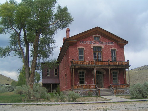
Donna and Jeff suggested that we take the road through Bannack on the way to Craters of the Moon National Monument. So we did, and we ended up reaching Bannack, Montana around lunch time the next day after camping in Wal-Mart. Bannack used to be the capitol of the territory of Montana, before it became a state. It was an old gold miner’s town. There was a long “main street” lined with many old buildings such as a school house, hotel, saloon, and other ghost town buildings. You could walk into most of them, and it felt like you were walking into the last century! The buildings were all from the mid-1800s. I guess some people still lived there up to the 1940s, but it was already largely abandoned by then.
Craters of the Moon National Monument
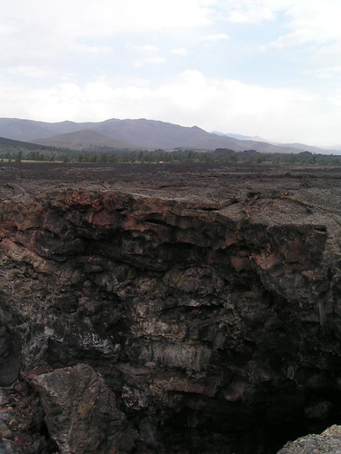
By the end of the day, we reached Craters of the Moon, in Idaho. We slept on a “scenic pulloff” just past the entrance to the park, but still inside the park territory. The night sky was so clear and there was no light pollution, so we saw all the stars! We even saw the Milky Way stretch across the whole sky! I wish I could’ve been able to take a picture. When we woke up, pretty early, a trucker joined us at the pulloff, and I guess he fell asleep with his head flat on the steering wheel, and we also noticed two empty bottles of beer next to his cab on the ground. Hehehehe. Craters of the Moon is an ancient volcano caldera, like Yellowstone is, but it has volcanic lava flows all over the place. The park is covered in aa lava and pahoihoi lava flows. There are many volcanic cones scatter along the place, which are the areas where the lava flowed out and that hole built up after the lava dried and flowed over it again. We took a little hike around one of the lava flows, and then took another hike to some lava tube caves! I never thought Idaho would have lava tube caves, but they were like the ones on Hawai’i. We went into one of them with our flashlight (the caves are wild and you can explore them on your own), but our flashlight sucked, so we went into the Indian Tunnel cave, which was caved-in at some spots, slowing light to pass through, so you didn’t need a flashlight. It was only 800 feet long, but it was pretty cool! Then we walked across the lava flow field back to the car, and continued on driving for the day.
Oregon and Crater Lake National Park
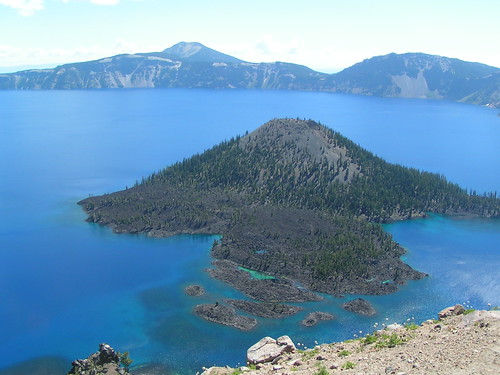
We came into Oregon in the afternoon, the same day we left Craters of the Moon. Oregon, in the east, is very dry and desert-like, much like southern Idaho is. Our next destination was Crater Lake National Park. But we didn’t reach it before sun down that day, so we camped about 50 miles away in some state park near the Oregon volcanic monument, an area of the Cascade Mountains that kinda resembled Craters of the Moon, with all the cones and old lava flows. For the first time, we hooked up the water hose to the bus, and we used the sink inside to wash dishes! It was so convenient. The next morning, we drove to Crater Lake NP. The lake is at the top of the now-collapsed Mt. Mazama, an ancient volcano. The caldera collapsed about 7,700 years ago in a huge eruption, and a lake formed fed by only snow and rainfall. We drove around it on the Rim Road. We stayed for a couple hours, and now we're off for the PACIFIC COAST!!!
Since the last post, we were just leaving Donna and Jeff’s place. We got a late start out of there b/c we had to fix a torn CV boot. We had the boot already, so all we had to go was take it off and replace it, and we also repacked the grease since the grease inside was all nasty from the dusty gravel roads. Well, we continued driving that night until we reached Missoula, Montana. It was getting dark out fast, and we weren’t going to reach any national forest roads before it got dark out for sure, but we did pass a 24-hr. Wal-Mart! Well, good thing, because we felt welcome to park and camp out in Wal-Mart’s parking lot for the night. When we pulled in, there were at least 5 other full-size RVs camping out, our neighbors even had their lawn chairs out and were drinking in the parking lot! Hahahaha!
Bannack Ghost Town
Donna and Jeff suggested that we take the road through Bannack on the way to Craters of the Moon National Monument. So we did, and we ended up reaching Bannack, Montana around lunch time the next day after camping in Wal-Mart. Bannack used to be the capitol of the territory of Montana, before it became a state. It was an old gold miner’s town. There was a long “main street” lined with many old buildings such as a school house, hotel, saloon, and other ghost town buildings. You could walk into most of them, and it felt like you were walking into the last century! The buildings were all from the mid-1800s. I guess some people still lived there up to the 1940s, but it was already largely abandoned by then.
Craters of the Moon National Monument
By the end of the day, we reached Craters of the Moon, in Idaho. We slept on a “scenic pulloff” just past the entrance to the park, but still inside the park territory. The night sky was so clear and there was no light pollution, so we saw all the stars! We even saw the Milky Way stretch across the whole sky! I wish I could’ve been able to take a picture. When we woke up, pretty early, a trucker joined us at the pulloff, and I guess he fell asleep with his head flat on the steering wheel, and we also noticed two empty bottles of beer next to his cab on the ground. Hehehehe. Craters of the Moon is an ancient volcano caldera, like Yellowstone is, but it has volcanic lava flows all over the place. The park is covered in aa lava and pahoihoi lava flows. There are many volcanic cones scatter along the place, which are the areas where the lava flowed out and that hole built up after the lava dried and flowed over it again. We took a little hike around one of the lava flows, and then took another hike to some lava tube caves! I never thought Idaho would have lava tube caves, but they were like the ones on Hawai’i. We went into one of them with our flashlight (the caves are wild and you can explore them on your own), but our flashlight sucked, so we went into the Indian Tunnel cave, which was caved-in at some spots, slowing light to pass through, so you didn’t need a flashlight. It was only 800 feet long, but it was pretty cool! Then we walked across the lava flow field back to the car, and continued on driving for the day.
Oregon and Crater Lake National Park
We came into Oregon in the afternoon, the same day we left Craters of the Moon. Oregon, in the east, is very dry and desert-like, much like southern Idaho is. Our next destination was Crater Lake National Park. But we didn’t reach it before sun down that day, so we camped about 50 miles away in some state park near the Oregon volcanic monument, an area of the Cascade Mountains that kinda resembled Craters of the Moon, with all the cones and old lava flows. For the first time, we hooked up the water hose to the bus, and we used the sink inside to wash dishes! It was so convenient. The next morning, we drove to Crater Lake NP. The lake is at the top of the now-collapsed Mt. Mazama, an ancient volcano. The caldera collapsed about 7,700 years ago in a huge eruption, and a lake formed fed by only snow and rainfall. We drove around it on the Rim Road. We stayed for a couple hours, and now we're off for the PACIFIC COAST!!!
Friday, August 03, 2007
Webb Mountain Lookout

Last night we stayed at the Webb Mountain Lookout near Eureka, Montana. We reserved it from the Eureka ranger station, which controlled the near areas of the Kootenai National Forest. We had to drive 30 miles to get to the lookout (which was one of the only lookouts you could actually drive to!), up a winding mountain road. The last 1/4 miles was really rough and washed out, but the poor VW made it! We had high enough clearance, although we got it up on 3 wheels, and the front end up!! Well, we made it and were rewarded with the view of sunset (above picture).
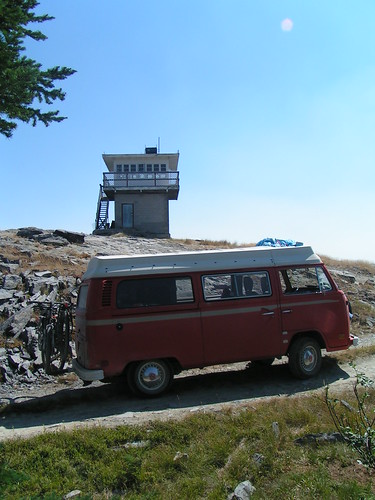
This is a pic of the VW and the tower above. The towers were used every summer for fire lookouts. Now they are not used, because they use airplanes to watch for fires, so they can be rented out. It was really cool to stay up there. We had nice views, but it was progressivly getting smoky out because a fire just started in Glacier NP (which we didn't know at the time). The deer came at sunset and made so much noise all night!
Well, the next morning, we went to visit Donna and Jeff, the people we bought the VW from last August, and we went bow shooting through a target course they made through their woods (they have 20 acres of land on the mountainside). It was fun! We only hit the target about half the time, but it was still so much fun.
Today we're going to continue to the Idaho panhandle into the mountains again. We posted more pictures of the lookout at the flickr picture site: www.flickr.com/photos/jennromyphotos
Wednesday, August 01, 2007
Canadian Rockies are HUGE!
Hi everybody!
Since the last post we were still in Glacier NP at Polebridge. Now we are in Eureka, Montana. We left Polebridge and drove down the Going-to-the-Sun Road, which took about 2 hours, and was very nice. It winded up and inbetween the mountains. We stopped somewhere along the middle of the road deep and high into the mountains to make lunch. We were planning on camping somewhere towards St. Mary's Lake at the east end of the park, but there was no room or something, so we decided to head North to Canada!
We crossed the border, after our poor VW bus was searched by two Canadian officers. They found nothing, of course, and it was quite funny how they were struggling to open the fridge!!! After a minute, they gave up and never opened it to see the beer we had inside. Hehehehe.
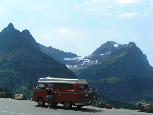
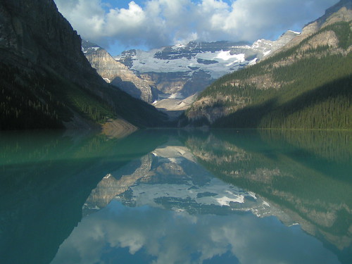
We camped out at Belly River campground in Waterton Park (the Canadian side of Glacier NP). There Romy finally gave in to washing up in the river after not showering for about 4 days. The water was not too cold. Anyways, the next day we made it to Banff, and camped out near Lake Louise. The Rockies up there are much higher! Almost 13,000ft peaks. In Glacier the peaks were about 9-10,000ft. We drove through Banff NP along the Icefields Parkway, which was a long chain of high mountains with huge icefields on top of then. We went by the Columbia Icefield and saw/walked on a glacier.
Later that day we made it to Jasper, had coffee, and moved back down to Lake Louise. That day was a lot of scenic driving. On that day we saw a ton of wild animals, most notably a black bear, a GRIZZLY bear, bighorn sheep, and mountain goats. The only animals we were missing were a cougar and a wolverine.
So now we are back from Canada and we will be staying around Eureka, Montana for a few days. Tonight we reserved a night at Webb Mountain lookout cabin, which was used in the 1950's and beyond as a lookout tower for wildfires. Now it is not used and people can rent it for up to 7 days from the Kootenai National Forest.
Thats it so far! See our pics on the flickr site!!!
www.flickr.com/photos/jennromyphotos
Since the last post we were still in Glacier NP at Polebridge. Now we are in Eureka, Montana. We left Polebridge and drove down the Going-to-the-Sun Road, which took about 2 hours, and was very nice. It winded up and inbetween the mountains. We stopped somewhere along the middle of the road deep and high into the mountains to make lunch. We were planning on camping somewhere towards St. Mary's Lake at the east end of the park, but there was no room or something, so we decided to head North to Canada!
We crossed the border, after our poor VW bus was searched by two Canadian officers. They found nothing, of course, and it was quite funny how they were struggling to open the fridge!!! After a minute, they gave up and never opened it to see the beer we had inside. Hehehehe.
We camped out at Belly River campground in Waterton Park (the Canadian side of Glacier NP). There Romy finally gave in to washing up in the river after not showering for about 4 days. The water was not too cold. Anyways, the next day we made it to Banff, and camped out near Lake Louise. The Rockies up there are much higher! Almost 13,000ft peaks. In Glacier the peaks were about 9-10,000ft. We drove through Banff NP along the Icefields Parkway, which was a long chain of high mountains with huge icefields on top of then. We went by the Columbia Icefield and saw/walked on a glacier.
Later that day we made it to Jasper, had coffee, and moved back down to Lake Louise. That day was a lot of scenic driving. On that day we saw a ton of wild animals, most notably a black bear, a GRIZZLY bear, bighorn sheep, and mountain goats. The only animals we were missing were a cougar and a wolverine.
So now we are back from Canada and we will be staying around Eureka, Montana for a few days. Tonight we reserved a night at Webb Mountain lookout cabin, which was used in the 1950's and beyond as a lookout tower for wildfires. Now it is not used and people can rent it for up to 7 days from the Kootenai National Forest.
Thats it so far! See our pics on the flickr site!!!
www.flickr.com/photos/jennromyphotos
Subscribe to:
Posts (Atom)
