Monday, September 27, 2010

A Day at the Beach

Today was really hot outside. There aren't too many of those kinds of day in the bay area, especially on the Pacific Ocean, because of the cold water. So what did we do? We decided to ditch the afternoon at Berkeley and go to the beach! Our favorite beach is Stinson Beach because its so big and there is free parking. It also seems likes it the warmest there, probably because its somehow protected from wind. Its right on the San Andreas fault near Point Reyes.

Stinson Beach
Our spot on the beach, complete with beach umbrella!


This was the first time that we actually brought a beach umbrella to the beach. The sun was really hot, so it was nice to have the umbrella. We found that umbrella on the street. Somebody was throwing it away because the stalk part of it was rusted and makes it hard to adjust the height. But we grabbed it when we saw it about a year ago, and its great! One man's trash is another's treasure.

Stinson Beach
Romy went swimming in the cold water!


There were a lot of sea gulls out. One of them was very interested in our bag of chips that we took with us. It was unopened, but the gull must of known what was inside. As soon as we stepped away from our towel, the sea gull went straight for the bag of chips. It decided to ram its beak into the bag and poke a hole into it. It did it with such force that it almost ripped the bag open entirely! We got back to the towels just in time to see it all go down, and chased the bird away. It stalked us for 10 minutes after that, waiting to go after the bag of chips again. It was very persistent, but eventually gave up.

Stinson Beach
We saw a pair of dolphins swimming in the ocean near the shore! The dark spot in the water is a dorsal fin.


As the sun was getting lower on the horizon, I was watching a surfer ride the waves. Then something else in the water caught my eye. I swear I saw two dorsal fins. They were huge! I got all excited because I thought they were orcas! So I yelled at Romy, "Orcas, orcas!" and he looked at me all crazy. Then I grabbed the camera and ran to the water. Once I got a better look, I realized they were actually two dolphins! They were jumping in and out of the water as they swam along the shore, and they were really close to the shore. I tried to take a picture but only got one where a dorsal fin is sticking out of the water. They swam around the surfer, who I don't think noticed them at all. It was really exciting to see dolphins in their natural environment, not at a zoo!

Stinson Beach
People at Stinson Beach.


Soon the sun was so low in the sky that it was starting to get chilly. So we decided to pack up and head home.

Sunday, September 26, 2010

Fall Finnon Fest 2010

Its already the third year that the Fall Finnon Fest has been going on! And its kind of exciting to know that we've been to every single one, since the beginning when we first moved to California! I don't really have much to say about the camp out, except the usual. It was fun and we can't wait until the next one. Here are some pictures to enjoy:

Fall Finnon Fest 2010
Brian's bus and his bike that he attached an engine to! Really epic!


Fall Finnon Fest 2010
Carl's adventure wagon with the hatch popped open. Will he end up selling it or not?


Fall Finnon Fest 2010
Somebody drove up Saturday evening in this Ghia. Not sure who it was, but I got this close up of the front lights.


Fall Finnon Fest 2010
Not sure who's bus this is, but I've seen it before. I appreciate the tarp awning!


Fall Finnon Fest 2010
Peter's red bus and Brett's big blue.


Fall Finnon Fest 2010
John's Dormmobile. Very unique - it was imported from the U.K., I think.


Fall Finnon Fest 2010
The hang out spot was by Shelby and Blake's Westy vanagon.


Fall Finnon Fest 2010
Saving the best for last! Our bus with Romy cooking breakfast and brewing some coffee on Sunday morning.

Monday, September 20, 2010

Kayaking on Mono Lake

Kayaks on the Baja
The baja carried our two kayaks over the mountains to Mono Lake.


I don't remember now what first gave me the idea to go kayaking on Mono Lake. But once it got into my head, I was determined to do it. Actually, I think it had something to do with hot springs (like all the crazy adventures, it seems). Somewhere I read that there was a hot spring on the big island (called Pahoa Island) on Mono Lake and the only way to reach it was by boat. The idea of visiting such a remote hot spring, which is three miles from the nearest launching point, made me want to go see it. I guess it was a similar motivation as the one I had to hike to Iva Bell, which was 13 miles from the nearest trail head. I then confirmed that it existed when I found a NOAA report from the 70s of all the hot springs in the US, complete with the GPS coordinates, water temperatures, and common name. From there I learned that the spring was so hot it was just 10 degrees short of boiling, and it was alkali. Not to great for bathing, but I wanted to see it anyways.

Mono Lake
Kayaking through/around the South Tufa formation.


Mono Lake is a small inland sea, but it is 3 times saltier than the ocean! Its so salty, that nothing really lives in it except tiny brine shrimp. It is actually one of the oldest lakes in America, so it has been accumulating salt for a long long time! The area is full of recent volcanic activity, the most spectacular being the formation of the islands on the lake. They weren't there 400 years ago! They erupted just 'yesterday' if you think about the area on a geological time scale. The numerous hot springs on the island, which gush forth fresh water, are what create the famous tufa formations that ring the shore. Each tufa was once an active spring and formed from the interaction between calcium that was dissolved in the spring water with carbonates in the lake water. Over time, the calcium carbonate built up into tall towers. These have a sort of eerie beauty to them.

Mono Lake
Posing for a picture by the South Tufa formation.


Our trip started on Friday afternoon. We packed up the baja, filling it with dry bags with all of our camping equipment and food inside. Then we loaded the two kayaks onto the roof rack and tied them down. We had a long journey ahead of us, so we double checked that they were secure. There is something funny about the tiny VW Beetle carrying two huge sea kayaks. The kayaks are longer than the baja and overhang the front and rear bumper by almost a foot! We always get a lot of looks and laughs as we drive by.

Mono Lake
Two lone Tufa far off shore.


Mono Lake is located on the eastern side of the Sierra Nevada mountains, where the high peaks drop sharply in elevation to the valley below. In the summer, strong winds develop in the afternoon that rip over the mountains and crash down into the valley. I think they are temperature/density driven. Winds over Mono Lake can reach hurricane force on a typical summer afternoon. All over the lake, there are signs posted warning of these sudden winds, and many people have died because they drowned or something when the winds picked up on the water. So it is recommended that you kayak only in the morning, and make sure you get to shore by noon or 1pm. In order to have enough time to kayak to the island and make it there before noon on Saturday, we drove over the mountains on Friday night and camped near Navy Beach in the mono craters forested area over night. The next morning we went to the visitor center as soon as they opened (8am) to pick up our camping permits.

Mono Lake
Paddling into the protected little cove inside Castle Tufa.


When we told the rangers at the visitor center that we wanted to kayak to the island and stay overnight, they looked at us with a kind of sad face. I was like, wtf? Then the expression on the ranger's face turned into a sort of "You won't like what I'm about to say, but. . . ." and he told us that there were high winds predicted for Sunday all day. He said,

"I don't recommend going out on the water and paddling to the island because on the way back Sunday there are 30 mile an hour winds forecasted for all day."

Damn. I was kind of pissed actually, because we hauled those things all the way here, and now we were thwarted by the wind! The prevailing wind direction was towards the island from Navy Beach, so getting there would be a breeze (haha, pun intended!) but paddling on the way back would be rather difficult and dangerous on Sunday. Finally then we asked him what he recommended that we do. He probably sensed that we were kind of disappointed, so he kept repeating that we could go if we wanted to, but he also kept stressing the dangers of it, and how many people had died on the lake due to the sudden strong winds (about a few people each year). I had no doubt about the danger, so I asked if it was okay to kayak along the south shore instead and camp overnight somewhere. He said that that was an excellent alternative, and then told us about all of the tufa towers and fresh springs along the shore we could check out. He also let us know where we were allowed to camp (anywhere except near the freshwater springs).

Mono Lake
Taking a break at Castle Tufa.


So although we weren't headed to the big island, we at least had a safe alternative, so we got back in the baja and took the kayaks to Navy Beach so that we could launch as quickly as possible before the afternoon winds picked up. Since all we had to do was stuff all of our stuff into the boats, we were ready within 1/2 an hour. Our first stop was the South Tufa formation which was very near Navy Beach. Its a really large formation and sees a lot of tourists (from the land). But it looks a lot different from the water!

Mono Lake
The Castle Tufa reflects off the glassy water of Mono Lake.


That morning the water was calm, and like glass. It reflected all of the tufa formations like a mirror. The only disturbance was when we paddled by. Near the South Tufa, but farther off shore, were two lone towers standing like pinnacles. We kayaked out to them and checked it out, and then started heading east along the southern shore of the lake. All surrounding the lake was sandy soil with lots of rubber rabbit bush in bright yellow bloom. They are my favorite desert plant because of their bright fall color.

Mono Lake
Blooming rubber rabbit bush on the shores on Lake Mono.


Soon we reached the Castle Tufa which was about 2 miles away from where we launched that morning. It stood like a fortress on the shore. But only when we got closer did we realize why it was really called Castle Tufa. As we paddled around it, we realized that there was a small protected cove inside the tufa formation. We carefully paddled inside and discovered multiply flowing fresh water cold springs coming out of some of the tufas! We washed our arms and legs in the fresh water, which by now were caked in salt crust from the splashes of salt water as we kayaked. What a relief! The salt was starting to burn my skin a little and made it feel dried and leathery. It also left a faint smell, very organic, slightly rotten and salty.

Mono Lake
Simon Springs on the southern shore of Mono Lake.


After a break, we paddled on, staying close to the shore. The water near the surface was filled with tiny brine shrimp. We took a good look at them and realized they were in almost all colors of the rainbow. Some were pink, creamy colored, and others were bright iridescent turquoise! They swam (but mostly just floated) around with what looked like a million legs to each side and a long skinny tail. I wonder what eats them? It looked like birds picked at the water every once in a while, but not that much.

Mono Lake
Exposed land tufa that was once under water when the lake level was higher.


Before we knew it, we reached Simon Springs, where we were supposed to camp for the night (well, not right at the springs because that isn't allowed). We got there earlier than expected, so we decided to go take a look at the marshy land that was surrounded by otherwise dry sandy desert. Reeds and cat-tail like plants grew all around, and there was an explosion of green. The spring area also had a few land tufa. Of course, these were formed when the lake water level was higher, and the tufa were submerged. The lake level has dropped nearly 40 feet since LA started diverting water for the city. Now its gone back up 10 feet since conservation efforts won some important battles for Mono Lake. But the state of California has come to an agreement that LA only needs to manage how much water they take so the lake level returns another 10 feet higher. That leaves the lake 20 feet lower than it would naturally be. The reason for this (we learned from the rangers) is that the state of California wants to leave some of the tufa exposed because it has become a large tourist attraction! Kinda screwed up, in my opinion, but in a weird way it makes sense. I would rather see it go back to how it naturally was, but then again, we were there partly to see the tufa, after all, like most people.

Mono Lake
Beached at our camping spot for the night.


It was already noon, but the winds were still calm. We decided to keep paddling farther down the shore to find a good camping spot. But like clockwork, about 20 minutes after we set off the first breezes blew by. Soon the breezes turned into gusts, rippling the surface of the water. The wind was coming from the west, from the mountains, and it pushed us from behind. We stopped paddling because the wind was becoming so strong enough that we literally didn't have to anymore. We saw white caps in the distance off shore between us and the big island, and the waves grew larger and larger where we were too. And then the wind was gusting so strongly, I started to get scared. The wind was catching on our paddles and rocking the kayaks back and forth. Just as the worst of it was beginning, we were blown towards a large sandy beach. We decided that it was a good spot to camp and beached our kayaks then and there. The rangers were not kidding about the winds being strong and sudden. One minute it was calm, and literally the next minute, we were being blown over!

Mono Lake
The view at our camp spot with the 'sheltory' tufa; the lake shining in the late afternoon sun.


It really couldn't of been a better spot to camp actually, which was lucky. But the wind was blowing so much that we looked for a place to shelter from it. Again, lucky us, the wind took us to the beach that had a broad tufa formation which, when we sat behind it, blocked about 90% of all the wind! We relaxed there for a while, munching on some trail mix of hazelnuts, brazil nuts, and chocolate chunks. After a nice break, we walked around the shoreline to check out the many exposed land tufa in the area. The wind stayed pretty strong for a couple of hours, but as the sun began to sink lower towards the west, getting closer to setting behind the mountains, the wind calmed down. Finally near sunset, it got calm enough to build our tent (which at first we had to weigh down with the gallons of fresh water we brought with, or it would of blown away).

Mono Lake
Romy jumping with a bottle of wine!


Camping with the kayaks was a sort of luxury. We had room to bring a lot of stuff and we weren't limited by weight! So we brought a bottle of wine for the evening. We also brought canned food and fruit (things we would never bring backpacking). And we had a lot of extra warm cloths. Good thing, because it was nice to change out of our salty cloths we paddled in and put on some comfy sweaters and sweatpants at night. During the day it was in the 70s, but after the sun set, it dipped into the 50s. Later in the night it got even colder, but stayed above freezing. The weather report at the ranger station said it was about 37 degrees, which was probably right before dawn. The skies were clear all night, and we had a bright moon that lit up the sky. For most of the night, there was a constant breeze. I hoped that it would stop by sunrise.

When we woke up just after sunrise about 7am, the wind picked up. We knew it was going to be breezy today, but I hoped that it would give us a little break. Not a chance. The wind had changed direction, blowing off shore and slightly in the direction against where we needed to paddle back to Navy Beach, 6 miles away. Well, once we realized this we picked up the pace and got ready to start paddling back as soon as we could before the wind got worse. Soon we were launching the kayaks again onto the choppy lake.

Mono Lake
Me at our camp spot with the sheltory tufa behind.


At first, we just started paddling along the shore parallel to it. But that wasn't working very well because the wind was blowing us slowly off shore and into the deeper water. It was doing it gradually enough that you couldn't notice, but once you did it was scary how far we were when we realized it. So we had to change our strategy and always paddle half way towards the shore and half way parallel to it. That way we were partially going towards our destination, and fighting the wind from pushing us into deeper waters. I was paddling with all my strength for the entire way back. I didn't take the camera out because the waves were breaking sometimes over the kayak hull, and salt water was splashing everywhere! Plus, if I stopped paddling for a second, I would start going backwards because of the wind. We took a break in the sheltered cove at Castle Tufa. Our faces were covered in white salty crust, and so were our arms! My hands looked like I had mickey mouse gloves on!

Anyways, we eventually made it back to Navy Beach, where we had the baja parked. What a relief! But I had mixed feelings once we got there. At first I was really happy that we made it without any roll overs or other problems. And then I was like, "Is it over already!?" I wanted to keep exploring the lake, but I guess there's always next time, right?

Mono Lake
Back at Navy Beach!

Saturday, September 18, 2010

5 Years of Blogging!

Today marks the day, five years ago, that I started blogging on www.jennandromy.com. It seems like such a long time ago! Wow!

Here are links to my favorite post of the year. Its like going back in time!

2005: Ode to Rafail Abramov, our linear algebra professor at UIC.

2006: We're Back From the Rockies!, a post about our trip to pick up our VW Bus after we got married.

2007: Canadian Rockies are HUGE!, a post about part of our cross-country trip in the VW Bus.

2008: We Made it to Berkeley!, a post about moving from Berwyn to Berkeley to start graduate school.

2009: Natural Hot Springs of the Eastern Sierra, a post about our first trip to visit the hot springs in Long Valley, the first of many!

2010: This year isn't over yet! But I still have a favorite post so far, Volcanoes, Aliens, and Hot Springs, a post about out trip to Washington (state) with Sebastian to watch alien ships fly over ECETI Ranch.

Wednesday, September 08, 2010

Fish Creek Trail to Iva Bell

This past labor day weekend, we took the opportunity to go check out Iva Bell Hot Springs. The hot springs are very remote, located at about 7,200 ft in the high Sierra Nevada in the John Muir Wilderness. From the nearest trail head, it is a 13.75 mile hike one way! I've heard of people going to the springs when there was still snow in the mountains, but usually it is only accessible in the late spring and summer months. We heard about the hot springs at Iva Bell from an older couple we met while soaking at the Crab Cooker hot spring in the Long Valley one cold November night. They told us that they were hiking along a trail up near Red's Meadow in the 80s when they stumbled upon a set of pools in the wild. Nobody was there except them! When I got home, all I remembered from their conversation was the word Red and the word Bell. I tried looking in my California hot springs book for anything but couldn't find the spring they were talking about. Then I kind of forgot about it for about half a year.

Fish Creek
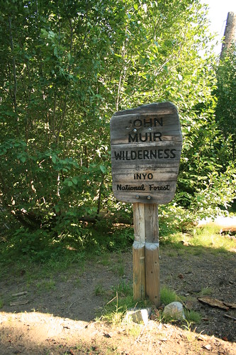
Entering the John Muir Wilderness.


Then I stumbled upon a blog online which was about a couple's PCT/John Muir Trail hiking journal. They mentioned a bathhouse which had showers fed by 100% hot spring water at a place called Red's Meadow campground near Mammoth Lakes, CA. That was a clue! I went on an internet researching frenzy typing in "Red's Meadow hot springs Bell" and finally found the spring that the couple found in the 80s. It is different than the spring that feeds the showers. After identifying the name and location of Iva Bell hot springs, I still couldn't actually find it in any hot spring guide. I guess its a word of mouth type of place. The spring is not marked on all maps either like others are. Well, after finding out everything I could, we were ready to try and find it for real! But we needed a long weekend to do it because we wanted to take two days to reach the springs, hiking between 5-8 miles per day, and two days on the way back. That meant we needed a 4 day weekend to do the ~27 mile hike, so we ditched school on Friday and created our own 4 day weekend out of labor day weekend.

Fish Creek
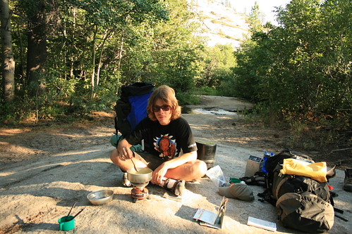
Tired Romy making a pasta dinner near the creek we camped at the first night.


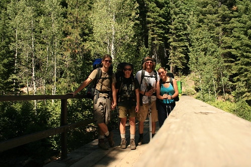
A few days before we left, Nicole called me and said that they were canceling their trip to Canada because of hurricane Earl, which was causing bad weather all along the East coast where they were planning to be vacationing. Instead they found cheap tickets to L.A. and were wondering what we were going to be doing over labor day weekend. I told them our plans to hike to the hot springs, and they wanted to go to, but they wouldn't be able to start the hike until Saturday morning, while we were going to be starting Friday afternoon. In order to make it to the springs with us, I told them they would have to hike the entire 13.75 miles in one day! They were okay with that so we made plans to meet up. We also made a plan B and a plan C. Just in case.

Fish Creek
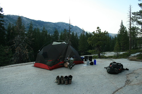
Our camp site on top of glacially polished granite.


Before heading into the John Muir Wilderness, where the springs are located, you need to secure an overnight camping permit from the ranger station. We got one almost last minute, and we were really happy that they had some left, being a holiday weekend and all! I think they only let 25 people stay in the JM Wilderness each night. Also, the bear box idea is going viral, so they also required all overnight hikers to store their food in bear canisters, which they rented out for $5 at the ranger station in Mammoth Lakes.

Fish Creek
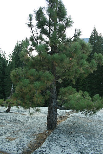
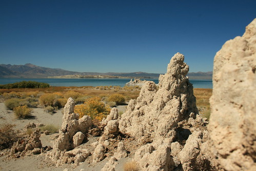
A pine tree growing out of what looks like solid rock! So crazy!


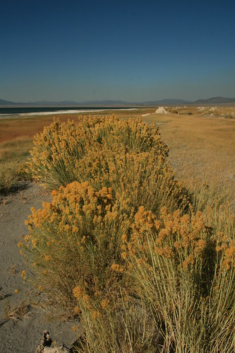
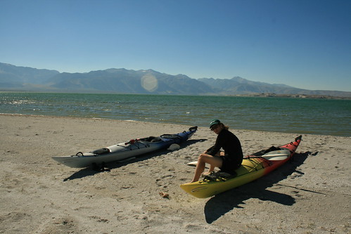
We started out the hike in Red's Meadow. In the summer, there is a mandatory shuttle which takes you into the Meadow. The same shuttle also goes to Devil's Postpile National Monument (which we didn't have time to see it though). After getting tickets on Friday afternoon, we hoped on the shuttle and asked to be dropped off at the Rainbow Falls trail head (also the Fish Creek trail head). The Fish Creek Trail is the one which goes all the way to Iva Bell hot springs, but the first mile of it also serves as a trail to Rainbow Falls, a nice waterfall near Red's Meadow. Its a very busy part of the trail, but after you get through it, the people disappear and we were basically alone. In fact, as we hiked to our first camp site, we didn't see anybody else the entire time! It was really hot when we started out. The first part of the trail goes through an area burned by a wildfire over 15 years ago. But it is still really bare with no new trees, just short scrubby bushes. The burned trees stood like masts in a sea of bushes and charcoal. We had a couple miles of this until the trail dropped down into the regular vegetation. Then we passed a dense area near a stream, and off in the distance, we heard a thump thump thump! It was a black bear and we scared it and it was running off in a crazy dash, kicking past downed logs and bushes making all sorts of noise! I guess we were not expecting a bear, and we were glad that it was more afraid of us than we were afraid of it!

Fish Creek
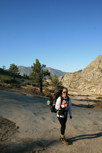
On our second day of hiking on the Fish Creek Trail, still a bit chilly out in the morning!


The trail then started heading for open and exposed granite, typical of the Sierra Nevada. We were nearing the 5 mile mark since we left the trail head, and since we had a long day already just to get to Red's Meadow from Oakland (we headed out of the house at 5am), we started looking for a good camp site for the evening. We soon found one near a creek which was feeding a waterfall farther down the trail. We spotted a nice flattened piece of glacially polished granite. It was literally like camping on top of a granite counter top, and it was shining in the sun. As the sun set, all of the heat that the rock absorbed during the hot day from the sun was radiating out of it. It was like sitting on top of a heater. We built our tent and relaxed. We were both pretty tired. The rock heated up our sleeping pads and we were so warm all night. The next morning, as we packed up our tent, we felt the rock under where we had the tent and it was still warm! The rock that was exposed to the night air was cold at the surface, but under the tent it was nice and toasty!

Fish Creek
Some of the trail was cut right out of the granite!


After breakfast we continued hiking. We had to go almost 9 miles that day to make it to the springs. We hiked through come beautiful country, granite domes, and tall pine forests. Then we descended almost 1,500 feet of switchbacks down into Fish Creek Valley along which ran the Fish Creek, where the trail got its name from. We got to a big wooden bridge called Island Crossing and took a long rest there. It was peaceful. We were just relaxing with the sound of the creek rushing under the bridge. The water was crystal clear. But it was time to move on because we heard the springs calling to us! We only had about 4 miles to go!

Fish Creek
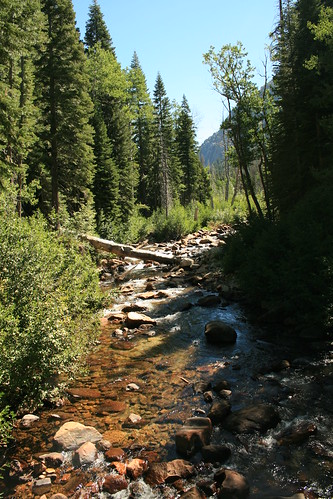
Fish Creek at Island Crossing.


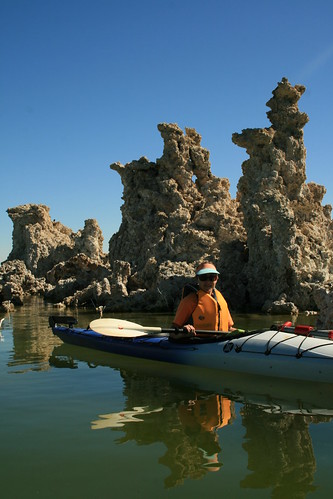
Boy did the last 4 miles seem more like 10! We had to ascend almost the entire way up back to about 7,200 feet, which is where we were before we descended all of the switch backs just a little earlier. Somewhere I read that the trail was mostly downhill. How did that person figure? We started the trail about 7,000 ft and we were going to end at about 7,000 ft at the springs so that's impossible. I guess you can't believe everything you read on the internet! But we were so close and we passed a few people hiking out the springs, each telling us that when we get there, we will reach paradise. We couldn't of been more motivated to keep on hiking! We heard from other hikers that the springs are not obvious from the trail at all. Once you get about 4 miles beyond the wooden bridge, there was a sign nailed to a pine tree which read "<--- Fish Valley, Goodale Pass --->". At that point we saw a small creek that we were instructed to cross over on a log. After that, we should see a few foot trails going up a hill. We followed one of the foot trails, which led us to a clearing. Except the clearing was filled with cascading water, flowing over rounded granite boulders nestled in lush grasses and wildflowers. Suddenly it seemed like all of the birds began to sing and we just kept hiking up, and up and up. We passed by a huge house-sized granite boulder, and came upon the first pool!

Iva Bell Hot Springs
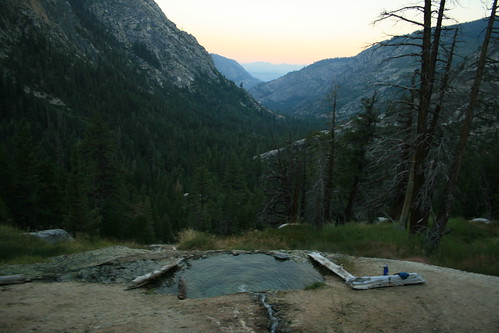
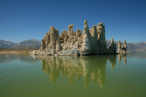
View of the morning sun coloring the distant ridges from the middle pools at Iva Bell.


The trail criss-crossed through the wet lush grass, and we walked through it to get higher up the mountainside where the other pools were located. Under the lush grasses was cascading spring water. It almost completely saturated the clearing. A small and very steep trail led us higher up the mountainside and soon we found the middle set of pools. They had an awesome view of the entire Fish Creek Valley.

Iva Bell Hot Springs
Cascading spring water and lush grasses at Iva Bell.


Being a holiday weekend, there were many other campers around. We counted 20 people including us! But everyone was tucked away in secluded camping spots, so it didn't seem like a metropolis. We were lucky to find the last camping site near the middle pools, so we snagged it and took a break. But it was the middle of the day so it was pretty hot to go into the hot springs yet. So we had a late lunch instead and contemplated whether of not we thought Nicole and Marcel would make it this evening. They started out the trail this morning, after an all night drive from L.A. We crossed our fingers for them! In the mean time, we escaped the heat of the open clearing where the hot spring pools were by hiking back down to the main trail and sat next to the Fish Creek. We sat there for a couple hours actually, just relaxing. We decided that we would wait for Nicole and Marcel until it got near dark out. We talked about a lot of unimportant things to pass the time, and dipped our feet in the creek. Then when the sun dipped behind the trees, we hiked farther down the trail to find an area we at first complained about because of the lack of shade. Now we wanted to catch the last rays of sun to keep up warm while waiting for N&M.

Iva Bell Hot Springs
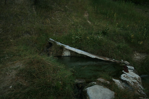
Another turquoise pool at Iva Bell.


To our amazement, at about 6:30pm, we heard a yell from the trail, "Hello!" It was N&M and they were a little earlier than we were expecting them! They made it! We took their backpacks and helped carry them back up the steep trail up to the middle pools where we were camped. They were so exhausted that they didn't even eat much of dinner (broccoli and cheese rice-a-roni). But as soon as it got dark, and the air temp cooled to a pleasant 50 or 60 degrees F, we got in one of the three middle pools. Other people were in the other two pools, but they were in there for a while already and soon left when we got in. So we basically had the entire set of pools to ourselves for the whole night! The water temperature was slightly over 100 degrees. We heard from some campers that had been to the springs long time ago that they used to be hotter, more like 110 degrees F. That's a better temperature for a hot spring in the dead of winter, but 101F was okay for cooler summer mountain nights. However, it was not hot enough to prevent bugs and other small floating things to die. So we were swimming with other life forms that evening too. But it was dark, so. . .

Iva Bell Hot Springs
Hot spring water cascades from one pool to another via small dug out channels in the earth.


We saw the sky covered in stars, and the milky way was thick and bright. We even saw 4 shooting stars! What a nice end to a full day of hiking! We had finally made it! It was so peaceful.

Iva Bell Hot Springs
Taking one more dip in the morning!


When we got out, we were pretty warm and dried off quickly. Then we stumbled back to our camp site and got into our sleeping bags for the night. Romy and I bivouacked instead of building our tent. N&M slept in their tent. It was a warm night. The next morning, when the sun came out, I woke up Romy and we went back into the hot spring one more time. Then we came back and had coffee and breakfast. Then N&M woke up and we all went back into the hot spring again! For all the people camping nearby, we were still the only ones out that early in the pools. It was nice! Everyone was still sleeping. Once the sun came up over the mountain ridge, we felt its heat and knew it was time to start packing up. We only had a short time at Iva Bell, but it was worth every mile! However, I wish the water was slightly hotter. There are supposedly two more pools even higher up the mountain which are supposed to be nicer, but we never hiked up there. Next time!

Iva Bell Hot Springs
N&M hiking past the middle pools out of the Iva Bell area.


Now we found ourselves hiking back, our third day. We wanted to take it easy, so we made sure to take plenty of stops. We hiked about 2 miles and took a long break. Then we hiked another mile and it was getting really hot out already, so we took another break to go swimming in Fish Creek. It was really refreshing! We cooled off, which was good because we had a lot of switchbacks in front of us. Soon we crossed the wooden bridge again and started our ascent. It was a whole bunch of up with a lot of steps! Somewhere half way up, a cowboy on a lone horse was coming down the switchbacks. We moved off the trail into the bush to let him and his horse pass, but he insisted that we pass and he would ride the horse off the trail. Poor horse! It was so scared! First of all, the trail was very thin and narrow, and second, the horse was big! And third, the mountainside was extremely steep. But he pulled the reins and told the horse to basically step off the trail and onto the steep mountainside. The horse was so scared its eyes got super wide open and almost refused to listen to the cowboy. But finally, after a lot of slipping and turning around, it stepped off the trail and let us pass. Then we told the cowboy that that was kind of crazy, and he told us is a hilly billy accent, "Oh, its normal."

Fish Creek
On the wooden bridge at Island Crossing.


After what felt like forever of going up, we finally reached the top! We drank almost all of our water though, so taking a break was just for the muscle relief. There was no water for another two miles. We relaxed and cooled down in the shade, and then continued to cold creek, the first place we could fill up on water and eat. But the hike up all of those switch backs exhausted us all and the two miles to cold creek seemed to drag by. When we finally heard the rolling creek, we perked up and hiked a little faster. Finally we made it and collapsed on the pine needle covered ground under the trees. We busted out our lunch, but it was already after 4pm! We had beef jerky and cheese, chocolate, hazelnuts, and a cookie. We also munched on a tomato.

Fish Creek
Are we at cold creek yet!?


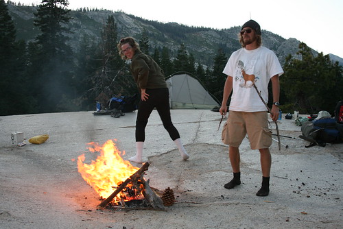
The good news was that we were now full of food, hydrated, and only a mile or so away from where we wanted to camp for the night. When we got to our camp site (the same place we camped the first night) we collected some fire wood and set up camp. We were still full from our late lunch, so we just relaxed and made a fire. Then later in the evening, we made a small dinner. The fire was hot since the wood around us was very dry. We made the fire in a little depression right on top of the granite, and sat around in our socks on the smooth warm surface. It was like nothing else ever before! What a luxury to not be surrounded by dirt ground but instead clean smooth warm rock.

Romy Rolling
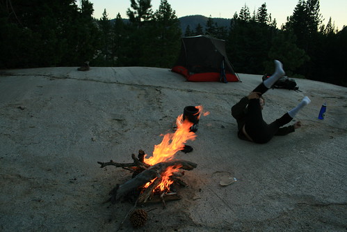
Romy being silly and rolling around the camp fire in his socks and thermal long johns.


Being Silly at Camp
What is going on!? I don't know but this is an epic picture!


The next morning, we had only 5 miles to go back to Red's Meadow where we planned to take a shower in the hot spring fed bathhouse! It was a easy hike until it suddenly started going up hill a lot! Then it was tough, especially the uphill sections at the end! We were so near the resort but the trail kept going up! Ahhhhhhh! We now all hiked 27 miles, and we ended it with a bang I guess. Finally we crested the "summit" and found ourselves at the Red's Meadow Resort. Marcel joked that he expected a large lodge with antler chandeliers and deer heads mounted on the walls. We found some cabins, a small store and cafe made from log cabins, and a campground. But most importantly, we found the bathhouse! There were about 6 showers, which flowed into concrete tubs in private rooms. When you turned the spigot, the hot water ran out and it was steaming hot! We cleaned off all of the dust and grit of the trail for the past four days. How nice! Then once we were all clean, we headed to the nearest bus stop and took the shuttle back to Mammoth.

Red's Meadow
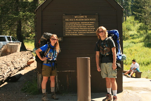
All clean after a shower in the hot spring fed bathhouse at Red's Meadow!


And that was the end of our 27 mile round trip adventure to check out Iva Bell Hot Springs! It was nice!