Thursday, April 29, 2010

Starting Out Our Own "Project Life"

I've been inspired after seeing a few other blogs on the internet (http://runningfromcamera.blogspot.com/) and YouTube videos of the people who take a picture of themselves everyday or almost everyday for many years (http://www.youtube.com/watch?v=6B26asyGKDo) to start my own similar project. Our friend Shelby, from the vwcamperfamily, first mentioned Project Life as a thing she was doing - taking a picture of herself everyday doing something normal in her 'everyday life.' I thought that was a really cool idea, and now I think I am finally going to start our own Project Life of Jenn & Romy. I will be posting the pictures on my flickr photo website in the set called A Foto Each Day. Here are the first two pictures of our project, taken today:


Jenn 4/29/2010
Jenn on the hill-line bus at UC Berkeley, going to school.

Romy 4/292010
Romy on the hill-line bus at UC Berkeley, also going to school.

Tuesday, April 27, 2010

Happy Times at 'Hot Tub'


Hot Tub Hot Spring
Romy at Hot Tub


I'm just remembering the fun winter trip we took to the hot springs near Mammoth Lakes. I never posted pictures from that part of the trip that we took in early March, so here they are. The valley was still covered in deep snow, so we hiked in to the nearest hot spring off of Whitmore Tubs Rd. The funny thing is that we had snowshoes with us, but we didn't think the snow was that deep. Think again! By the time we realized we should of put them on, we were already too far away from where we parked the car to make it worth it to go back.


Walking to Hot Tub Hot Spring
Hiking to the hot springs.

Friday, April 23, 2010

Working on My Master's Degree

I haven't been posting to the blog lately because I have been occupied by finishing my master's degree in mechanical engineering at UC Berkeley. I am working with Prof Buffett in the earth science department, and my research is in geological fluid mechanics. As required, I had to write a thesis on my research topic, and I also have to do an oral presentation of my work. I finished writing the thesis about one week ago (yay!) but now I am making the presentation, which is much easier now that the thesis is actually done. What is it about? That's what you're probably wondering now. Well here is the title page:


title page of my thesis
My master's thesis title page.


So I realize that the title probably sounds like a foreign language, so let me explain. What I've been studying is fluid flow through ocean sediments. Sediments, as they fall onto the ocean floor, are continuously being buried, and as they get buried deeper, they are squeezed and compacted. Much like a sponge, the sediments squeeze out any water that might have been trapped when the particles fell to the ocean floor. This fluid that is squeezed out behaves according to physical laws (ie fluid mechanics) and can be described mathematically. Even the environment, like the ocean sediments, can be described mathematically. I have been studying how all these equations come together to describe fluid flow through the ocean sediments. In particular, I am modeling how fluid flow is effected by an anisotropy in the sediment permeability. The permeability of 'something' (in this case being ocean sediments) is a word that described how easy it is for a fluid to flow through it. If the permeability of the sediments is anisotropic, it means that fluid can flow through it easier in one direction than another. In nature, it is often found that fluid can flow easier laterally (side-to-side) through sediments than vertically (up-and-down). So if you introduce topography, it might be able to focus fluid flow through the sediments, like in the picture:


focusing
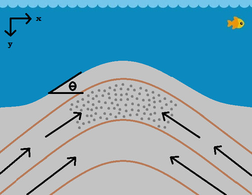
Fluid flow might be focused up and into the topographic high on the sea floor. The stripes represent different fluid layers. The arrows represent fluid flowing.


So what's the point of all this? Well, those gray dots in the picture are supposed to represent methane hydrate, a reservoir of methane gas (a.k.a. natural gas) that is frozen in ice. Its so cold underneath the ocean floor that some water trapped in the sediments freezes, and within the ice crystals, methane gas is trapped. The methane comes from bacteria that eat organic things in the sediments. In fact, most of the sediments are made of dead ocean animals, so the methane is coming from their decomposition, aided by bacteria. The point is that there is A LOT of methane trapped in this way under the ocean floor, and its relevant to study how fluid (which carries dissolved methane gas) flows through the ocean sediments, especially since the accumulation of methane hydrate is mostly found under topographic highs. Basically, there are mountains and canyons underneath the ocean, just like there are on land, and underneath the mountains, it seems that methane hydrate accumulates more than in other places. So there. . . hopefully the title is not as mysterious now.

Saturday, April 17, 2010

Kayaking For the First Time in Cali

We didn't bring the camera with us kayaking because we were afraid that we'd tip the kayaks, so we only got this one picture before we left:


The Baja and the Kayaks
The baja with two 17ft sea kayaks on top, ready to go!


Yes, thats the tiny baja, dwarfed by our two 17ft sea kayaks on top. Its really kind of funny to see it in that perspective. When we bought the kayaks almost half a year ago from a guy in Petaluma, we were afraid that we wouldn't be able to get them home because they were so long. In fact, we took the bus to pick them up, thinking that we'd fit them in, but they were even longer than the bus by 3 feet. We ended up keeping the back hatch on the bus slightly open and driving with the kayaks sticking out the back. The front of the kayaks went right up to the windshield! This prompted us to check out how long the bus actually was, and compare it to the baja. Did you know that the VW Bus is only one foot longer than a VW Beetle!? Could you believe that!? And all this time, I thought that the Beetles were so tiny and compact. How amazing it is to figure out that the VW Bus is only one foot longer than a Beetle!!!! In actuality, the VW Bus should be labeled as 'compact!'

Anyways, we got a lot of looks and thumbs up and calls from bystanders on the street as we drove the two kayaks to Lake Chabot, just a few miles south of where we live. It was really funny! And it was a beautiful day to go kayaking for the first time in Cali and for the first time in our very own kayaks! We'd wanted to get our own for a long time and one day we found an awesome price on craigslist. We were looking for two matching sea kayaks, and we found them and had to act fast (you know craigslist). The guy selling them said he developed back problems which made it painful to sit in the kayak for more than an hour. The other kayak was his friend's, who married a rich Mexican woman and now lives in a castle in Mexico with his wife, and left the kayak with his friend in Petaluma, Ca. Now he was trying to get rid of them, and sold us all of his accessory gear with them, like paddles, skirts, neoprene gloves, bilge pump, etc. It took us a while to get our own life vests and roof rack gear to carry them, but now that we finally got everything together and the weather was starting to warm up, we finally took the kayaks out. It was fun!

Tuesday, April 13, 2010

What's Up With L.A. Taking All the Water?

In our recent jaunts to the eastern side of the Sierra Nevada mountains, be it to go to the desert, the mountains, or visit the hot springs, we've encountered many signs of land and water being "owned" by the LADWP. Like signs saying, "No Overnight Camping Allowed - LADWP land." After a while, we wondered who LADWP was. Then we figured out that its actually the city of Los Angeles and LADWP stands for Los Angeles Department of Water and Power. So why the hell do they own so much land so far away from the city of LA?

Its because they need to own the land so they could have the right to suck all of it dry! And its very apparent when you drive down HWY 395 and look at all of the "lakes" like Mono Lake or Owen's Lake. In the case of Mono Lake, the LADWP started diverting water out of the river that fed it in the early 1900s and the water level dropped like a rock. Conservation efforts in the 1970s and 1980s stopped them taking as much water as they liked, and now the lake is actually rising again, but its still below its natural level. What's amazing is that Mono Lake is roughly on the same line of longitude as San Francisco, but LA is taking its waters. In the case of Owen's Lake, its even worse. LA completely sucked it dry. It turned from a salt lake like Mono to a salt playa in the 1920s, and now it whips up alkali dust every time there is a wind storm. The people who lived around it complained so much from the dust 'pollution' that LA agreed to wet the soil a bit to prevent dust storms. In fact, one of our professors at Berkeley was part of the scientific study which showed how the wind patterns in the Owen's Valley made the dust storms so bad. She studies how the wind (air) flows over mountains and in mountain valleys. She said that the dry lake bed which was once Owen's Lake was the largest point source of dust in the western hemisphere! Could you believe that!? After the study was published, that's when LA decided to start wetting the soil. However, when we drove by Owen's Lake a couple weeks ago, during a crazy wind storm, we could see the dust storm for miles away!


Owen's Lake Alkali Dust Storm
An alkali dust storm on Owen's Lake


The wind was really ripping across the Owen's Valley and picking up a lot of salts and other minerals and dust that cover the now dry lake bed. The cloud formations show just how windy the valley was. The low clouds over the Sierras to the left are caused by condensation of moist air over the mountains. The air is moving very fast downwards into the valley where it dries up, and picks up a lot of dust. In fact, the winds can get so strong that they knock over semi trucks driving on Hwy 395! Then the wind flows back up over the White Mountains to the right, forming this huge front of clouds that runs parallel to the valley. These are the crazy winds that pick up all of the dust and create a hazard when it is windy.

Not only that, but you can't even camp in the Owen's Valley because LA owns it to take water from the Owen's River. Many natural hot springs pop up in that valley and the run off drains into the river, which is tapped by LA. Therefore, LA doesn't want any new hot tubs built which would interfere with their water supply (even though they wouldn't at all), nor campers who would just like to enjoy the pleasant scenery.

Sunday, April 11, 2010

A Wild Horse


Wild Horse
A wild horse near Death Valley Junction, CA


Its not everyday that you can still see wild horses roaming around the west. But every time we drive through the Chicago Valley area, which spans the desert basin between Shoshone, CA and Death Valley Junction, CA, we seem to see one or more! The area is managed by the BLM especially for the wild horses, believed to be left over from old ranching operations. Now the horses are wild and free, and every once in a while, you can see them traveling in herds, or alone (like the one we saw in April). According to what I understood from the BLM, the herd size is managed to about 12 horses in the Chicago Valley. Their population is a controversial topic, because technically they are not native. All the wild horses in the west are descended from abandoned or escaped ranch horses. If their population gets larger than what the BLM has set as the limit to "maintain ecological balance," then they are periodically removed (nevermind that the BLM is highly influenced by ranchers, who don't like wild horses interfering with their cattles' well being). The wild horses are literally rounded up and sent to a government training program, or offered to the public at auctions or adoption agencies. Sometimes they are killed and the meat is shipped to Asia (I'm not joking!). There was a great article in National Geographic in the February 2009 issue about wild horses in the west. From there I learned that many of the horses that are rounded up and trained are actually trained by prison inmates (government cheap labor) and later sent to other government institutions where horses might be needed, like the mounted police. Its all very interesting if you look into it. Now that I know, it seems to spoil what I had in my head about the iconic wild horse in the west. They aren't really free and wild after all. :-(

Tuesday, April 06, 2010

Death Valley Wildflower Bloom


Death Valley Wildflower Bloom 2010
Death Valley is in full bloom!


In the past winter, Death Valley has gotten as much or more rain as it normally does in a whole year. Even so, it isn't what many people would call a lot of rain, just 3 or 4 inches. This year's El Nino like weather helped all of the wildflower seeds sprout, and now they are in full bloom! Most of the flowers are in the southern part of the park, where many of the seeds were deposited from the last big bloom in 2005.

We went to see the wildflower bloom and took a lot of pictures of the individual flowers that we found blooming. As we drove further south, the alluvial fans began to turn bright yellow, covered with the most dominant wildflower, Desert Gold. I am including pictures of the flowers we saw and their common name.


Death Valley Wildflower Bloom 2010
Desert Five-Spot


Death Valley Wildflower Bloom 2010
Brown Eyed Evening Primrose


The Brown Eyed Evening Primrose blooms only at night. At dusk, the flower begins to open, and by early morning, when the sun hits it, the petals shrivel up and fall off. The best time to see them in during sunset.


Death Valley Wildflower Bloom 2010
Desert Chicory


Death Valley Wildflower Bloom 2010
Desert Gold Poppy


Death Valley Wildflower Bloom 2010
Arizona Lupine


Death Valley Wildflower Bloom 2010
Golden Evening Primrose


Death Valley Wildflower Bloom 2010
Bigelow Monkeyflower


Death Valley Wildflower Bloom 2010
Notch-Leaf Phacelia


Death Valley Wildflower Bloom 2010
Rock Nettle


Death Valley Wildflower Bloom 2010
Beavertail Cactus


Death Valley Wildflower Bloom 2010
Pebble Pincushion


Death Valley Wildflower Bloom 2010
Desert Dandelion


Death Valley Wildflower Bloom 2010
Desert Paintbrush


Death Valley Wildflower Bloom 2010
Fiddleneck


Death Valley Wildflower Bloom 2010
Mojave Aster


Death Valley Wildflower Bloom 2010
Globemallow


Death Valley Wildflower Bloom 2010
Turtleback


Death Valley Wildflower Bloom 2010
Goldcarpet


Goldcarpet is a rare Death Valley endemic plant. It only grows near the badlands by Furnace Creek. Its extremely tiny and its more like ground cover instead of a flower. I swear I also saw the same plant, except the tiny flowers were white in the southern part of the park growing in a wash. I wonder if its a different plant or not. I didn't take a picture!


Death Valley Wildflower Bloom 2010
Joshua Tree Bloom


The Joshua Tree bloom really smells gross, like old cheese.


Death Valley Wildflower Bloom 2010
Toothed Dodder


The Toothed Dodder is a parasitic orange vine that grows on top of host plants. I'm not sure if it ends up killing them, but when I touched the vine, it was very moist and plump, so I'm sure it steals a good deal of the host plant's water.


Death Valley Wildflower Bloom 2010
Desert Gold