Sunday, October 30, 2011

The Dingo Races at Prairie City

This past weekend was the last race of the season for VORRA. The Dingo has been in first place for the entire season, mainly because we've been consistant in showing up to all of the races and we always finish (which is actually a big deal)! We finished the season with first place in Class 11. Yay!

VORRA Prairie City
Romy is ready to get in the car for the first moto of the day as co-driver.

VORRA Prairie City
These are the pits where everybody lives for the weekend. Lots of VWs in our pit!

VORRA Prairie City
Romy is getting strapped in the car before one of the races.

The race this weekend was a double header. Two full days of racing plus three fun races at the end. We came in the bus so that the camping would be more comfy. Since the race was a short track, we were able to sit in bleacher style seats and watch the cars race around the whole track. In the desert races, the tracks are many many miles long and go off in the mountains. You basically never get to see the cars except when they pull into the pits. It was fun to watch all the big trucks. We were the only Class 11 to race this weekend, so when we were "racing" they put us with other classes. Mainly other classes with VW air-cooled engines and funny looking Suzuki things. Romy got to be the driver for two of the 6 motos. He was co-driver for two others. I got to be co-driver for the 4th moto with Bob as the driver, and it was so much fun! It really feels like you're going super fast, but really you're not! Its just because you're going off road, ripping through all the bumps, skidding around in the muddy sections, and going over jumps. Nothing too bad happened to the baja except a weird persistent oil leak from one or sometimes both valve covers. Towards the end of the races, one of the drivers, Dave, overheated the engine by driving the car after the alternator belt popped off. The engine didn't sound very good after that, but it was the last race. Lots of work ahead in getting ready for the next season!

VORRA Prairie City
I look so funny in the racing suit and helmet. I look like a little kid!

VORRA Prairie City
Packing up the Dingo to take it back home (which is the Santa Cruz Mountains, south of the Bay Area).

Lynda brought her hula hoops which she made out of irrigation tubing. She taught me how to hula hoop and it was so much fun and totally addicting. Especially when the super decked out team next to us in the pits started blasting music. They were all drunk watching us hula hoop. We had a mini audience. Lynda gave me a hula hoop to take home. I got Romy addicted to it too! Watch out Burning Man 2012! Saturday night was a lot of fun because Bob brought an old drum out of a washing machine and it became our fire pit. The tiny holes punched in the drum looked so cool as the flames made them glow all crazy. Best fire pit ever. We told a scary story around the campfire, since it was right before Halloween. It was the kind of story where one person adds a sentence, and then passes it on to the next person. The story turned out really funny. One guy kept changing the weather every time it was his turn!


A video of Romy getting strapped in the Dingo for the 5th moto.

Monday, September 05, 2011

The Desert Dingo Races in Fallon

Desert Dingo
The Desert Dingo and Skittles take off, into a cloud of dust.

Over Labor Day Weekend, VORRA held a 24-hour endurance race. It was split over two days, Saturday and Sunday. Each day you had 12 hours (from 8am to 8pm) to get as many laps that you could on the 40-ish mile track. It went winding along the basin and range Nevadan desert, over playas and winding up canyons over the ranges. It was dusty as hell, but surprisingly not that hot!

Desert Dingo
The start of race day #2 on the playa outside of Fallon, NV.

It only got up to 90F, but you know, "Its a dry heat." So it was very manageable as long as you were in the shade. Romy got to the race early on Thursday night to help put the baja through tech inspection. The rest of the team arrived Friday night or Saturday morning. A lot of the people on the team were actually at Burning Man, so there were a few people helping out this race who normally aren't on the team.

Desert Dingo
The Desert Dingo pulls into the pits.

Romy had a lot of fun driving the car during both days of the race. I had my first dust experience (which I had avoided until this weekend), and realized that the dust isn't that bad. Its so fine that you don't even notice it, except when it combines with the grease in your hair and forms a sticky form of natural 'hair product.' It gets all over, and can't be avoided, so you just have to accept it.

Desert Dingo
Another shot of the Dingo in the pits, and Crusty's cool old truck.

Three Class 11 cars started the race, and we were the only to finish! One of the Class 11's broke down on the first lap on the first day due to a busted transmission. They put in a stock transmission another team gave them, and managed 1-3/4ths of a lap before that one broke as well. Then they just started partying. The other class 11 (Skittles) made it through most of the race but were taking it slow. They seemed to stop a few hours before the race ended, but I'm not sure why. We were able to finish 12 laps over the 24 hours! (7 on the first day, 5 on the second) Thats pretty damn good! Actually, it pretty amazing that we FINISHED the race without breaking down like the poor other bajas! This means that the Desert Dingo is still in first place in our class. Yay! First place! But, we did break both shock towers off the front, punch a huge hole in the drivers side fender, and totally screw up the front suspension. Fun!

Next are some pictures I took as the sun was setting at the end of race day #2. The Dingo was on its last lap, but most cars were already done, so the air was quiet, calm, and clear. These next pictures are why I like the desert. Especially at sunset!

Nevada
Nicole and my shadow.


Nevada
Beautiful blue sky and poofy clouds.


Nevada
The sun burst through some clouds to give this shot a glowing effect. I did not photoshop this at all!


Nevada
I saved my favorite for last. Typical basin and range landscape under a sky speckled with nice clouds.

Sunday, August 28, 2011

Backpacking the Hoover Wilderness

Hoover Wilderness
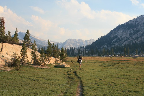
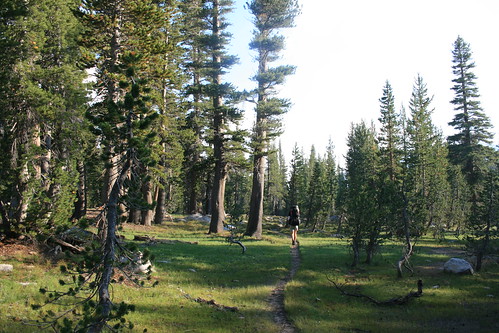
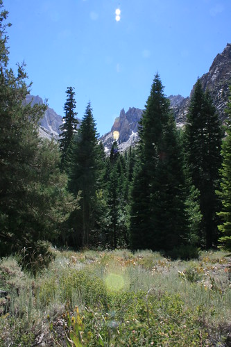
Kerrick Meadows inside Yosemite National Park.

I never knew about the Hoover Wilderness until Romy found a random topo map a few days ago at REI and decided we had to plan a backpacking trip to check it out. Its funny that we never thought of it before, since we've been around the area so many times (its just west of Bridgeport and the Buckeye Hot Springs). Well, we finally made a trip. Romy was kind of in charge of planning it, and he had a good idea about trying to do a thru-hike instead of a loop. It turns out that Marcel & Nicole were also planning a hiking trip for the coming weekend, and they wanted to go to Yosemite, so we asked them if they wanted to hike in the Hoover Wilderness instead (close enough). We would start at one end of the trail, and leave our car there. Nicole & Marcel would start at the opposite end, leaving their car there, and we would pass by each other somewhere in the middle. That way we had a car at each end and didn't have to loop back. We could just do one long thru-hike, never having to repeat the same scenery or terrain.

Hoover Wilderness
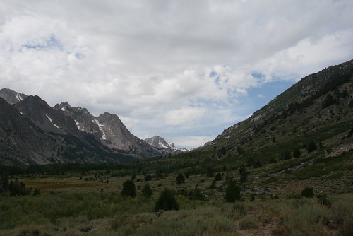
The view as we hiked up-valley along Buckeye Creek.

We started out Saturday morning after getting our hiking/camping permit from the ranger station in Bridgeport off of Hwy 395. You need one to camp in the Hoover Wilderness. We had to tell them where we were planning on hiking, and give them a quick itinerary. We planned on starting at the Buckeye Campground Trailhead, hike up the valley following Buckeye Creek, and then go south through part of Yosemite towards Peeler Lake. Then we would hike out via the Robinson Creek Trail, past Barney Lake, and out at Mono Village. The whole hike was about 25 miles long, and split up between two days was not bad.

Hoover Wilderness
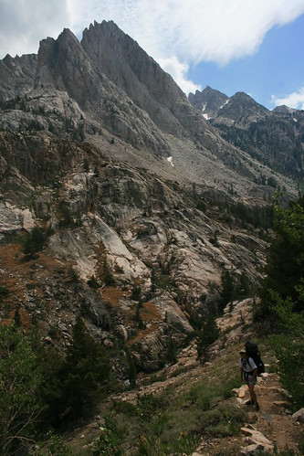
Hiking past gigantic mountains on either side of the Buckeye Creek, nearing Buckeye Forks.

We started out strong at the Buckeye Trailhead. It was hot and dry and sage brush was growing all around us, giving the air a nice smell to it. But it wasn't long before it turned into a muddy, marshy cow pasture! We quickly lost the trail, but we were confined to a pretty narrow valley, and we knew according to the topo map that we were to stay hiking up the valley. The cows were very curious, and some even ran towards us to get a better look. This part of the Hoover Wilderness is the least hiked, and it was pretty obvious because the trail was not maintained at all. At first we tried avoiding getting out feet muddy, but after a while we couldn't do it any longer. Romy almost lost his shoe in some ankle deep mud! But luckily, he pulled it out after a hard fight, complete with the funniest suction sound as his foot came out of the mud, happily with his shoe still on! We joked that we had "feet of mud." Every stream we had to cross we made sure to wash our sandals and legs clean. There were a lot of "dissolved" cow pies in the mud.

Hoover Wilderness
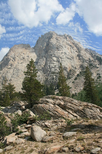
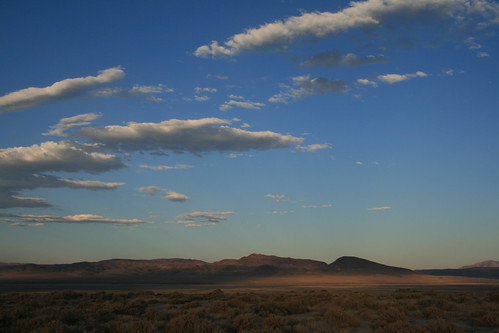
Cool clouds in the sky above huge granite peaks.

Eventually we got out of the mud and back on solid ground. Soon we actually entered the Hoover Wilderness, and the cows were no more. We started climbing a little more steeply, and began getting deeper into the mountains. The granite peaks rose high above up on both sides. The sage brush began to disappear, and we hiked through stunted aspen trees, and large pines. Soon we got right up next to Buckeye Creek, which was so crystal clear! We stopped to have a lunch break by the creek around 2pm after hiking about 8 miles. Our goal was to do at least 11 miles that day. After lunch we kept hiking, and soon we got to Buckeye Forks, where the trail splits in two. There was a small cabin, or shelter thing that was in disrepair, but okay I guess if you were stuck in a storm or something. Also, there were soooo many mosquitoes all of a sudden. I kind of was not expecting them so high up in the mountains.

Hoover Wilderness
We reached the Yosemite Park boundary and that means we're up and over Buckeye Pass!

We took the left fork that went south, towards Buckeye Pass, which was 9,000+ feet. We had plans on camping somewhere just before the pass. I was starting to get pretty tired as we hiked towards the pass, but after the trail forked, we only had one or two miles left before we decided it would be okay to stop for the day. But Romy had this crazy amount of energy, which he thinks is due to recently starting the gluten-free diet, and he wanted to hike all the way to Peeler Lake, which was still 4 more miles! I wasn't sure, since my feet were getting pretty tired, but after a few breaks, I was feeling okay to keep going.

Peeler Lake
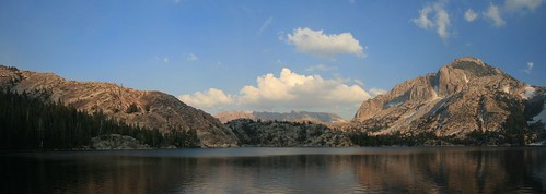
A panoramic picture of Peeler Lake, where we camped Saturday night.

The trail towards Buckeye Pass was very flat, and was filled with nice meadows and sparse pine forests that had a lot of stunted trees, from the altitude. It made me feel like I was walking around through a different land, where everything was miniature or something (except the huge mountains surrounding us). It didn't really look like we were hiking towards a mountain pass at all. We were walking through meadows of wildflowers and a meandering creek. Before we knew it, we had reached the summit, which also meant we were entering Yosemite National Park, which the trail crossed through for about a mile or so, before heading back into the Hoover Wilderness. We couldn't camp in Yosemite because we didn't have a bear canister for our food, so we were forced to move on to Peeler Lake. The Yosemite part of the trail was really beautiful, especially Kerrick Meadow. We stopped there for a break before finding a camping spot next to Peeler Lake.

Hoover Wilderness
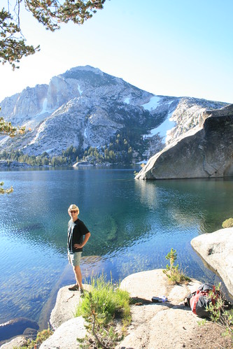
Romy standing at Peeler Lake in the morning.

We didn't see any other human beings the entire 15 mile hike from Buckeye to Peeler Lake, but as we got to Peeler Lake, we saw about 5 people! I guess its a popular spot! Some people were illegally camped too close to the water (you need to stay 100 feet away at least) which was kind of annoying. They have that rule on purpose, so that when you look at the lake, you don't also have to look at tents and stuff. We found a nice spot on the granite outcrops surrounding the lake, south of the trail. Unfortunately there were mosquitoes here too, so we quickly built the tent and got inside, away from the bugs. We didn't put the rain fly up, just the mesh part, so that we could see through the mesh and look at the sunset cast different colors on the mountains and clouds. Then at night, we were able to see the sky really clearly, and we saw the milky way.

Hoover Wilderness
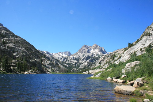
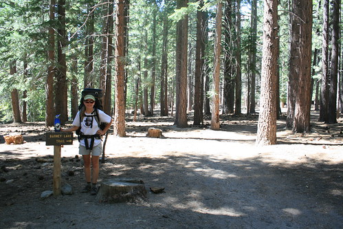
We spent an hour or so at Barney Lake, where we met Nicole and Marcel.

The next morning we woke up when the sun hit us and it started getting hot. It was about 7:30am. We only had 8 easy miles to go to Mono Village. After breakfast, we packed everything up and hit the trail. It was all downhill from here. As I started hiking, I noticed that both my achilles tendons were hurting when I hiked. I figured out a way to walk so that they didn't hurt. I basically had to limp so that my feet would stay flat. I had to take lots of breaks, and it made the last 8 miles seem really long! But at least they were downhill, and most of the route was shaded out of the sun.

Hoover Wilderness
Sage, pine trees, wildflowers, and granite peaks filled our weekend.

When we finally got to Barney Lake, we were expecting to meet Nicole and Marcel, who started their hike that morning in the opposite direction. We got there around 11am, but they weren't there. So we decided to wait for them since it was such a nice spot to sit and relax. After 40 minutes, they came trudging by, and we were so happy to see each other. That meant our plan B, plan C, and plan D (reporting each other missing to the ranger station) didn't have to happen. We almost went swimming in the Lake, since it was so warm, but then the wind kicked up. . . .

Hoover Wilderness
We finally made it to the end of the trail at Mono Village! We are triumphant!

I wish we could've stayed there forever, but we had to start hiking the last leg of the journey. We made it to Mono Village in less than two hours, and i was sooooo happy to see the car because of my feet. But we were also warm and all sweaty since it was getting really hot outside. So we decided to go swimming in the Twin Lakes by Mono Village, but couldn't figure out why there wasn't a beach. So we just pulled off the side of the road and took a plunge. IT WAS SOOOOO COLD! I almost had a heart attack when my body met the cold water and I was out just as soon as I jumped in. Thats why there is no beach! Needless to say, we cooled off very nicely, and felt refreshed for our long, long, long drive home. We really like the part of the hike that went through Yosemite, so I think we will be returning shortly, as soon as my tendons heel up. Get it!? LOL!

Wednesday, August 24, 2011

Another Earthquake!

earthquake2
A map of shaking intensity from the USGS 'Did You Feel It?' website.

earthquake2
The beach-ball diagram for the earthquake.

There was another earthquake that we felt this morning, just a few minutes before 10am. It was only slightly weaker, a magnitude 3.5, and the epicenter was almost in the exact same place as the magnitude 3.6 last night, on the Hayward Fault near Lake Chabot! For somebody who has never felt an earthquake before, all of a sudden we have two now! This is so exciting! This time, I felt that the shaking was a little bit different. I was opening the dresser drawer in the bedroom ("getting changed" LOL) and I felt a strange strong pressure pulse in my ears. It was completely silent, but it felt like the pressure pulse you feel if you're parked on the side of the road and a big ass truck passes you by fast. My first thought was that it was actually a big truck going down the street, but that would be a crazy big truck for me to feel a pressure pulse so far away and inside the apartment! I'm not a seismologist, but maybe I felt the P wave passing by. This wave is usually not felt by humans, but it makes animals go crazy, because they are sensitive to it. Anyways, right after the pressure pulse, the shaking started but it was very short. I would estimate at most 2 seconds, and it rattled some stuff in the bathroom and on top of the dresser. Here is a link to the USGS report.

Our First Earthquake!

earthquake
USGS's 'Did You Feel It?' shaking intensity map.

We've been living in California for just over 3 years, and it was only last night that we finally felt our first earthquake! It wasn't anything crazy, but it did shake the house a little. The shaking started just before midnight. I was sitting on a chair in the living room reading the newspaper, when it sounded (and felt) like a huge truck was going by on the road. At first I didn't think anything of it. But then it started to get very choppy and uneven in the shaking, and began to get stronger. It was very weak shaking, because nothing fell over, but I heard the walls shifting and the art wall panels hitting the wall as they were slightly jostled. If I was sleeping, I don't think it would of woke me up. I think the sound of the walls shifting and the panel jostling made the shaking seem more intense than it really was. It only lasted 3 seconds or so. Five minutes later, there was a small aftershock which I didn't feel, but I saw posted on the USGS website.

earthquake
The beach-ball diagram of the earthquake.

The USGS report said it was a magnitude 3.6, and the epicenter was just south of Oakland, at a depth of 9.1 km. I think it was on the Hayward Fault, which is the major fault that runs along the East Bay, less than one mile away from where we live!!!!! Also on the USGS's website, you can report the intensity of shaking that you felt on their 'Did You Feel It?' webpage. You report what you felt, and they organize it by zipcode. Then they post the results live, as people in the area go online and report in. It looks like most people who reported in thought the shaking was weak to light, intensity III - IV. I reported in an intensity III last night. Its kind of funny to see some really excited people who report high shaking intensities, higher than the vast majority of the people who live really close to the epicenter.

Tuesday, August 16, 2011

A Lost Whale

The night before we left everybody at the EPS grad student camping trip last weekend, one of the new grad students told us about a whale that swum inland, from the Pacific Ocean up the Klamath River, and was just hanging out under the Hwy 101 bridge. Although it was out of the way, since the Klamath River is farther north than we already were by Trinity Lake, we thought it was totally worth going to see a whale before heading home on Sunday! I never saw a whale in real life before.We hoped it would still be there. The Klamath is also in Redwood National/State Park, so we were able to take a detour through the park on the way to the bridge over the river. We saw huge redwoods, and there was little to no fog along the coast so it was warm. The last time we were there in the park with the bus was in 2007, the year before we moved, so driving along north through Redwood was almost like a bus-redwood reunion!


A video of the whale surfacing for air.

I was really excited to see the whale. It took us about two hours of driving to get to where it was. As we got near the bridge, we were really hoping that the whale would still be there, since it had already been swimming in the river for about a month. When the bridge was in view, we saw some orange cones and a scrolling sign that said, "Caution, people on bridge." As we drove over the bridge to get to some parking on the other side, we saw tons of people gawking over the side of the bridge and down into the river. Yay! That meant the whale was still there! After we parked, we literally ran back onto the bridge and got a good spot for the whale watching. The whale was just swimming back and forth under the bridge, as if it was parading for us to see.


Another video of the whale and the Klamath River.

The river was very shallow, so the whale was really visible and it came up for air often. After half an hour of parading under the bridge, it started swimming farther upstream, then stopped, still in view. At that point, a seal started swimming around, and it was munching on some fish it caught. The whale never came back towards the bridge again, but we waited anyways for another half hour. Then we decided it would be a good idea to head back home, since it was already about 4pm and we were very far north still (almost at the Oregon border).

Klamath River Whale
The Klamath River whale, as seen from the bridge.

Apparently, the whale swam up the river with her baby in late June. The mother whale stayed in the river, but the baby ended up swimming back out to sea a month later. Today, I just read online, it beached itself on a sandbar and sadly, died. The scientists studying it don't know what the cause of death is, but they are doing an autopsy. It might of been sick before swimming into the river, or it might of got sick while in the river. It will be buried on the banks of the river, and the whale bones will belong to the Indian tribe, whose land surrounds the Klamath River. While it was alive, people have been coming to the bridge to watch it every day and night, and some people even played music for it (hippies), and some people swam with the whale (crazy hippies)!

Klamath River Whale
People watching the whale as it swims under the bridge.