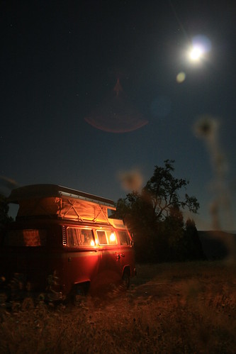
The bus under moonlight and the old Deitz lantern, up high in the Mendocino National Forest.
We never went exploring in the Mendocine NF, so it was all new for us. Our journey started with a drive up Hwy 101 until we got up almost to Ukiah, CA. The mountains started to get taller and taller as we drove north, and being that we were looking for a place to camp, I checked out the map to see if there would be any good spots nearby. The only forest land I saw was north of Clear Lake, which was east of the highway, so we stopped on the side of the road near Hopland to see what the best way to cross the mountains into the Mendocineo NF was. As we pulled off the road, we saw what looked like another VW Riviera stopped on the opposite side of the road. So of course we had to say hi! They were a nice and friendly family from Orange County (in southern California) doing a trip along the coast. Their bus was actually a Westfalia, but they replaced the pop top with a Riviera style one instead. Thats because Riviera pop tops are the best, and those with a Westy don't know what they're missing ;-)! Once we introduced ourselves (halfway through the conversation) they recognized our name because they actually had read my blog online. I was kind of surprised - I had no idea people were actually reading the random adventures I write about occasionally, and I'm glad that some people are enjoying it! They gave us some good camping tips, and also explained how to replace our pop top with new canvas from BusDepot.com, which inspired us to make plans to order a new pop top because ours has some tears and the zippers are kind of stuck. Now that we predominantly camp in the Sierras or the desert where bugs don't exist, it hasn't been too much of a problem, but it would be nice to have a good functioning pop-top. Anyways, random meetings of VW people are always fun.
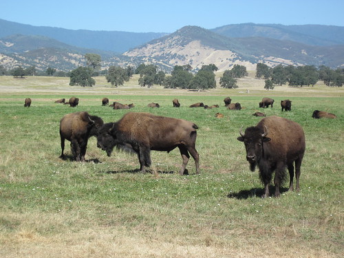
NorCal farmed buffalo between the Coast Range and the Central Valley.
It happened that right out of Hopland was a two lane paved road that went over the Mayacamas Mountains and to Lakeport. Then it was a short drive north of the lake to Upper Lake (very original name again) and into the Mendocino NF. The road (road M1) into the forest first followed a small river, and then started climbing up into the endless rolling mountains of Mendocino county. By this time the sun was getting low on the horizon, so we pulled off the road as soon as we were almost at the top and there was a convenient flat area where it looked like people camped before. The moon was almost full and overhead all night. It was quiet and warm overnight. We used the Deitz lantern as our source of light and ate dinner by lantern-light, pasta with pesto out of tupperware and a 'classy' box wine poured into a plastic wine cup. Dinner in the bus always tastes better.
A video of the bus crossing the water.
The next morning, our goal was to meet up at Trinity Lake to go camping with the EPS people. Since we were on the scenic route agenda, we decided to find a road that went through the Mendocino NF, while also trying to be as direct as possible towards the Shasta area. We found three possible roads. One was close to 100 miles of dirt forest roads which eventually met up with Hwy 36. Another two others were a compromise of about half that distance, give or take about 15 or 20 miles and an unknown elevation gain. We decided to go with the shorter two routes, which were roads M10 and M3. M3 branched off from M10, but both eventually got to Hwy 5 near Redding. So after breakfast, we started on our way. The road turned dirt soon after the junction of M1 and M10, and we saw a lot of dirt bike trails. We even saw some early morning dirt bikers riding along through the forest. The trees were a mix of pine and chaparel type shrubs like manzanita with the red bark. The soil was kind of reddish beige. The dirt road was very well graded and for a while we were able to drive pretty fast. But then the switchbacks started as the road took us deeper and deeper into Mendocino county and we had to slow down. About 25 miles or so down the road, we came up to a small river. There was no bridge. We had to drive through it! So I got out and waded across the river to see how deep it was. It was only a little past my ankles for most of the way, so we decided to drive through it to get across. I took a video of the bus's first river crossing (the one on Pacheco road doesn't count!).
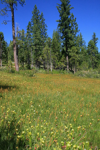
A field full of pitcher plants in the Trinity National Forest.
Soon after, M3 split off from M10. We decided to keep going on M10. Almost immediately after the split, the road quality degraded. There were ruts and deep holes, with rough gravel patches. Then it went up really high along the top of a ridge, called Long Ridge, with death drops on both sides! I didn't get a picture, cuz I was clutching my chair so tightly. Romy noticed I was kind of 'stiff'. It was one of the first times I was actually scared on a forest road! It went on like that for about 5 miles, and then back down. All the while we were kicking up a lot of dust because the roads were very dry. Soon we were over the mountain range and dropping back down towards the central valley. We had the option of getting onto Highway 5, but of course we were on the scenic route so that really wasn't an option. Instead, we stayed on the outskirts of the mountains and drove north, parallel to the highway along farm and ranch roads. Most of them were also dirt, but all were very well graded. We passed by a buffalo farm. It seemed like we were in Yellowstone! I wonder if they are the buffalo that Trader Joes makes buffalo jerky with. They all looked like very happy California buffalo.
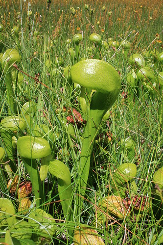
A close up of the pitcher plants we saw while hiking.
Before we knew it, we popped out of the ranches and into Red Bluff by Hwy 5. We didn't see any road that we could take as an alternative, so we got onto Hwy 5 at that point and drove north to Redding, where we exited to get on Hwy 299 West. At this point, we followed the directions I printed out to get to Trinity Lake. Right out of Redding, the road climbed up back into more mountains, and we even had some great views of Mt Shasta along the way! The theme of this trip was definately driving through mountains. This isn't really so hard to do in California, since the only flat part of the state is the central valley, and we did our best to avoid it. We got to the group campsite at Trinity Lake just about 4pm, 24 hours after we had left the day before. Nobody was there, since they all went out hiking for the day, so we picked a camping spot and took a swim in the lake. It was soooooo warm! Almost like swimming in a heated pool. Eventually everybody came back from their hike, so it was dinner time, along with copious drinking around the campfire under a full moon.
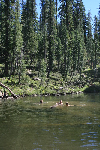
Swimming in one of the many mountain lakes in the Trinity National Forest, trying to roll a log.
The second day camping at Trinity Lake, we took a group hike to Lake Elanor, and also to another lake a few miles beyond, which was high up in the mountains. Along the way, we saw a whole meadow of cool looking pitcher plants! The hike to the second lake had over 1000 feet or so of elevation gain, so by the time we got there we were all hot. The lake looked so clear and inviting so of course we had to go for a swim. The water was suprisingly warm for its elevation, but it was also pretty shallow, about 10 feet deep. It didn't have a lot of vegetation, so that was good. Everyone had fun swimming, especially when we tried to have a log rolling contest in the water! After having lunch there, we headed back down (which was much easier hiking) and met with the rest of the group who stayed back at the first lake. When we all got back to the camp site, we were all hungry and ready for a cold beer. So the second night followed just like the first, with dinner around the campfire and more drinking. Sunday was the last day, when we all sadly had to go home!

1 comments:
Love that Moon shot! Great Pic!
Post a Comment